PORTLAND, Ore. (KOIN) — East Portlanders are questioning whether the distribution of proposed Safe Rest Village sites that the city released is equitable as some have noted there are several examples of higher-income neighborhoods with zero proposed sites, while lower income neighborhoods have multiple in comparison, among other issues.
The city released a list of 68 proposed village sites to temporarily house people experiencing homelessness last month, but only six from that list will ultimately be selected for development. Officials have said they will be outdoor shelters–not tents–and all six will be constructed before the end of the year. It’s unclear when the six finalized sites will be announced by the city.
Arlene Kimura, President of the Hazelwood Neighborhood Association, said she noticed that while Hazelwood has two proposed sites, and there are several others in surrounding neighborhoods, there are none proposed in neighborhoods like Eastmoreland, Bridlemile, and Laurelhurst, all of which are neighborhoods in the top 20% of median household income compared to the rest of the city, according to income data reviewed by KOIN 6 News. Hazelwood lands in the lowest 20% of median household income, by comparison.
“Why is it that those areas that have a modest income if not a low income, are the ones where you people say, well that’s where they are so we can put them up. Well, maybe not necessarily that’s where they are but that’s where they got pushed out to,” Kimura said.
Ann McMullen, who is also an HNA Board Member, added that she doesn’t understand why there are no Safe Rest Village sites at a place like Laurelhurst where a large encampment was cleared out near Laurelhurst Park late last month.
“[T]here is no Safe Rest Village planned for Laurelhurst where there is an obvious need,” McMullen wrote in an email (emphasis McMullen’s). “There has been a sizable encampment near the park off and on for years and the city has had to clear the camp multiple times at great expense to tax payers while at the same time inflicting trauma on the houseless living there via forced displacement. It is obvious the houseless people the city keeps forcibly removing from Laurelhurst Park are going to stay in the general area – they’ve stated as much in multiple news interviews. So why not site a Safe Rest Village in Laurelhurst so houseless people actually have somewhere to go other than living on the sidewalk subject to sporadic sweeps?”
KOIN 6 News looked into how the distribution of Safe Rest Village sites breaks down, per neighborhood, and plotted the below interactive map that shows just which neighborhoods have Safe Rest Village sites proposed and which don’t. In some instances, clusters of markers are representative of one proposed site which spans multiple parcels of land owned by the city. For instance, the Columbia Buffer Strip area located near 3043 N Trenton St. spans over 35 land parcels, according to the city’s own Safe Rest Village proposal list:
KOIN 6 News wanted to compare the above map to how each neighborhood’s median household income breaks down. We got in touch with David Banis, Associate Director for PSU’s Center for Spatial Analysis and Research, who provided a map he created with a rough estimate of each neighborhood’s associated income bracket.
Banis said the median household income data, broken down by neighborhood, is derived from averages from the U.S. Census Bureau’s American Community Survey from 2015-2019, which may have a margin of error of about 10%. And to calculate the MHI to be neighborhood-specific, converted from census-tracts, that margin of error may be even greater.
“No one’s going to get an exact number. And a lot of real estate websites have all sorts of information. But they’re going to calculate it in some manner in which we did this,” Banis explained.
He said more accurate MHI data will come after more of the recently-released 2020 Census data is analyzed. Until then, these estimates are most useful for comparison purposes, Banis said, for instance determining which neighborhoods have the highest vs. lowest income percentiles compared to the citywide average:

The number of neighborhoods in each income bracket is fairly evenly split, with roughly 18-20 neighborhoods in each level in Portland. When it comes to the distribution of the shelter sites compared to each income bracket, a striking pattern does emerge, which is the higher up the income bracket you go, the fewer shelter sites have been proposed.
- Neighborhoods with a MHI of ≤ $60,540 have 30.9% of total proposed shelter sites
- Neighborhoods with a MHI of ≤ $71,504 have 25% of total proposed shelter sites
- Neighborhoods with a MHI of ≤ $87,188 have 20.6% of total proposed shelter sites
- Neighborhoods with a MHI of ≤ $109,021 have 17.6% of total proposed shelter sites
- Neighborhoods with a MHI of ≤ $165,975 have 2.9% of total proposed shelter sites
- 2.9% of total proposed shelter sites were located in neighborhoods where income data was not applicable and/or not available (this includes unclaimed Multnomah County at Lake Yard).
The question arises whether areas of the city with a higher density of surplus, city-owned land may naturally be places with lower-income people by nature of those areas being less walkable, and less desirable in terms of real estate values.
“These things are acting together. But sure, it’s not just one thing. But, be that as it may, there’s been a camp at Laurelhurst Park Annex for a long time,” Banis said.
Banis said he lives about a mile away from the camp and has seen the aftermath from the most recent sweep around the end of July.
“As soon as they broke up that camp, you saw people all over the place. People didn’t go far, I think everyone knows that right. All the sudden, there were little congregations all over the place, just not at Laurelhurst Park Annex,” he said. “all you need to do is live around here to know that.”
KOIN 6 News reached out to the office of Commissioner Dan Ryan, who is the city leader charged with the task of narrowing down the Safe Rest Village sites list to just six and eventually developing them. In response to our inquiry, in which we raised the equity concerns HNA brought up, we received a prepared statement.
The statement said the village sites will include wraparound services for people experiencing homelessness and gave a few points of clarification:
“(1) We have made no definitive decisions about any site for a Safe Rest Village. The list is an inventory of City-owned land parcels. When City Council unanimously passed the Shelter to Housing Continuum earlier this year, it directed city bureaus to identify properties (aka “surplus land”) under their purview. Some of these properties will not be suitable for Safe Rest Villages, and we are still connecting with jurisdictional partners to identify additional properties that may be more ideal.
(2) City staff are working closely with staff from the Joint Office of Homeless Services to evaluate these potential alternative shelter sites—our top considerations are square footage, utility hookups, access to transit, environmental impact, and duration of availability.
(3) While some neighborhoods have more surplus land than others, that will not impact where Safe Rest Villages are sited—we will choose locations based on their suitability.
(4) If you have a property that you would like to explore using for a Safe Rest Village, please contact our office at CommissionerRyanOffice@portlandoregon.gov.
(5) We are currently hiring staff that will lead the next steps of this initiative, and we will have more information to share in the future. Please don’t hesitate to reach out in the interim as we move this work forward.
(6) While we remain on track to build these six Safe Rest Villages before the end of the year, we will ensure that neighbors are included, find locations that have all the amenities we need to succeed, and take our time to get this right.”
Back in January, a Bureau of Planning and Sustainability memo was submitted to the volunteer citizen Planning and Sustainability Commission with four maps, one of which laid out “Potential Outdoor Shelter Sites by Neighborhood Allowed Under Clear and Objective Standards.” The map showed some neighborhoods have a larger amount of potential sites located within them than others.
The accompanying Jan. 22 memo stated that “Although availability is not equally distributed throughout the City, every neighborhood has at least some sites available for an outdoor shelter.”
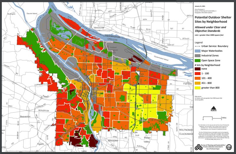
Although the number of proposed homeless sites becomes fewer and fewer as you go higher up on the income scale, it does also appear, based on the map above, that lower-income neighborhoods generally also have a higher-density of potential shelter sites that would be allowed by the city:
- No Potential Outdoor Shelter Sites Allowed Under Clear and Objective Standards
- 50% of the neighborhoods under this category have an MHI of ≤ $165,975
- 25% of the neighborhoods under this category have an MHI of ≤ $109,021
- 25% of the neighborhoods under this category have an MHI of ≤ $60,540
- 1-100 Potential Outdoor Shelter Sites Allowed Under Clear and Objective Standards
- 41.7% of neighborhoods under this category have an MHI of ≤ $165,975
- 25% of neighborhoods under this category have an MHI of ≤ $109,021
- 16.7% of neighborhoods under this category have an MHI of ≤ $87,188
- 8.3% of neighborhoods under this category have an MHI of ≤ $71,504
- 8.3% of neighborhoods under this category have an MGI of ≤ $60,540
- 101-400 Potential Outdoor Shelter Sites Allowed Under Clear and Objective Standards
- 17.5% of neighborhoods under this category have an MHI of ≤ $109,021
- 27.5% of neighborhoods under this category have an MHI of ≤ $87,188
- 35% of neighborhoods under this category have an MHI of ≤ $71,504
- 20% of neighborhoods under this category have an MHI of ≤ $60,540
- 451-800 Potential Outdoor Shelter Sites Allowed Under Clear and Objective Standards
- 12.5% of neighborhoods under this category have an MHI of ≤ $109,021
- 25% of neighborhoods under this category have an MHI of ≤ $87,188
- 12.5% of neighborhoods under this category have an MHI of ≤ $71,504
- 50% of neighborhoods under this category have an MHI of ≤ $60,540
Among the other concerns HNA raised, one thing they think would make the distribution of the Safe Rest Villages more equitable is if the city adjusted the Shelter to Housing Continuum code such that denser neighborhoods zoned for multi-use, like Hazelwood, have the same limitation on the number of residents in outdoor camps and villages as single family-zoned neighborhoods. Currently, multi-use-zoned neighborhoods can allow up to 60 residents of outdoor camps and villages, while single-family-zoned neighborhoods limit that number to 20.
Kimura said Hazelwood is not an appropriate choice to develop a Safe Rest Village because it already has around 300 low barriers beds for homeless people, with 175 at the Blackburn Center and 125 at Wyeast. In addition, she said one of the proposed sites is across the street from a retirement community that specializes in memory care, Russellville Park. A Mount Hood Community College Head Start site is also co-located in that same building.
“It is a complex solution and everybody has to help. And what we’re saying is, some people are being asked to do more than others. Why is that? How equitable is that?”
For an even more in-depth data breakdown of how the proposed Safe Rest Village sites are dispersed by neighborhood, check here.