PORTLAND, Ore. (PORTLAND TRIBUNE) — A new report about the Riverside Fire analyzes potential hazards resulting from the 138,151-acre incident.
The Erosion Threats Assessment and Reduction Team released the document on Monday, Jan. 11. The group, led by representatives from the Federal Emergency Management Agency and the state of Oregon, assessed potential erosion risks, flooding potential, hazardous trees and ecological impacts, as well as treatment recommendations.
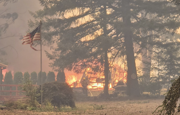
The Riverside Fire, which began in early September, destroyed approximately 57 homes and damaged an additional 10 homes and 186 minor structures. It reached full containment in December. Suppression costs are estimated at $21,000,000.
The land impacted by the Riverside Fire is owned by the Mt. Hood National Forest, Bureau of Land Management, and commercial and private forest lands under authority of the Oregon Department of Forestry.
Multiple elements were categorized as “very high risk,” including: trees damaged by the fires falling on roadways; boaters and swimmers being impacted by hazardous trees and floating debris on the North Fork Reservoir; threatened and endangered fish habitats from impacts to water quality; and native plants within and adjacent to the burned area.
According to the report, an estimated 72 miles of road have trees that were killed or damaged by flames within falling distance. Additionally, there are more than 265 acres of hazardous trees within the 100-foot buffer surrounding all structures. It was recommended that roads remain closed until the risk from the trees is mitigated.
In terms of water quality, loss of shading from plants will lead to increased stream temperatures.
“A number of (streams) experienced complete or partial loss of trees in riparian areas. This will result in increased solar radiation entering streams until vegetation regenerates,” the report stated. “Temperature increases are likely to last multiple years (potentially 10+ years in high burn severity areas) thereby impacting several generations. In a number of locations, stream temperatures during summer were already close to the thermal tolerance limits for fish species.”
“High risk” elements include: debris impeding travelers on Highway 224; debris impacting Promontory Marina Estacada and the North Fork Reservoir Dam; and contaminated water quality impacting habitats for sensitive, threatened and endangered species.
There were also several “high risk” elements related to plant life, including risk to native plant communities and wildlife habitats, and an increase in noxious weeds. Additionally, accelerated erosion may damage soil productivity.
“As initial assessments of damages are completed, the state and its partners are developing plans for recovery and rebuilding and analyzing potential costs of the recovery … as the first step,” a website with analyses of the Riverside, Holiday Farm, Beachie Creek and Archie Fires stated. “As these plans form, the state’s recovery progress will depend on available funding and resources.”