PORTLAND, Ore. (KOIN) — Multiple wildfires are raging across parts of Oregon right now amid a heat wave, forcing nearby evacuation notices and on a statewide level, causing smoky and hazy air conditions.
On Thursday, thunderstorms in Klamath and Lake counties created a new fire, called the Patton Meadow Fire, about 14 miles west of Lakeview in southern Oregon.
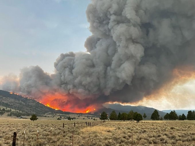
As of 4 p.m. Friday, the fire is now burning about 7000 acres , and has resulted in multiple evacuation levels, including Level 3 “Go Now” notices.
A Level 3 “Go Now” notice has been issued for Juniper RV Park to Patton Meadow and all of Drews Gap on both sides of Oregon State Highway 140. Level 2 “Get Set” notices have been issued for north of Highway 140 from Juniper RV Park to Lower Cottonwood, while a Level 1 “Get Ready” notice has been issued for east of Lower Cottonwood Road and Cottonwood Creek.
Gov. Brown invoked the Emergency Conflagration Act for the Patton Meadows Fire, which put firefighters from other districts moving to help fight the blaze. The Oregon State Fire Marshal requested a task force and crews from Portland, Gresham and Corbett deployed Friday afternoon. This is PFR’s eighth wildfire deployment this fire season, officials said.
Meanwhile, at the Skyline Ridge Complex near Canyonville, firefighters are planning burn outs to secure the flanks of the Poole Creek Fire after stopping spot fires that burned earlier this week, according to the Oregon Department of Forestry. The Skyline Ridge Complex fire, which started Aug. 1 after lightning strikes, is about 28% contained and at just over 4,100 acres, or nearly 6 1/2 square miles.
ODF reports these control efforts along with some cooling trends and little wind “have fire managers feeling guardedly optimistic about containing the Poole Creek Fire in coming days.”
Meanwhile, the 200-acre O’Shea Fire east of Canyonville, still part of the Skyline Ridge Complex, has been mopped up about 100 feet into the interior of the fire, according to officials. Level One “Get Ready” evacuation notices for the area south of the South Umpqua River along the Tiller Trail Highway is still in effect.
In the Cascades near Oakridge, the Middle Fork Complex, which has been burning since July 29 with Oregon Gov. Kate Brown invoking the Conflagration Act, is at nearly 7,000 acres, with about 2% containment. The complex consists of 12 fires, with three main fires: the Kwis Fire, the Gales Fire and Nine Mile Fire. The largest of the three is the Gales Fire, as fire crews continue to try to establish an anchor point on the northwestern side of the fire. Meanwhile, fire crews are preparing control lines between the southern edge of the Kwis Fire and the community of Oakridge.
Evacuation levels for the complex still stand as of Aug. 12, with Level 3 notices for all homes, campgrounds and recreation sites along Forest Service Road 18 (Big Fall Creek Road), including Puma Campground and Bedrock Campground. A Level 2 notice is in effect for High Prairie area, the Fish Hatchery area, Oakridge north of Roberts Road and Oakridge east of Salmon Creek, while Level 1 notices are in effect for Oakridge and Westfir on both sides of the river, including Deception Creek Mobile Park and the Hills Creek Reservoir area south of Highway 58 to Larison Cove, Belknap Hot Springs and Resort area and structures near Scott Creek and Highway 126.