Editor’s note: This weather update is from Sunday, Feb. 7, 2020. Click here for an updated weather blog with the latest winter weather outlook.
PORTLAND, Ore. (KOIN) — It’s out there! A whirlpool of bitterly, dense Arctic air engulfing the North Pole. One hiccup in the atmosphere and a frozen maelstrom is unleashed into the lower latitudes where you and I live. Don’t try to run because there’s no escaping the polar vortex!
Ok, let’s put the drama back in the bottle and uncork the facts.
First, the polar vortex is not a “thing” that shows up on your doorstep. It’s the cold air that escapes the vortex that’s potentially dangerous for the midlatitudes.
So, what are the chances this Arctic air will reach the Pacific Northwest? What about Portland? I know you’re seeing snowflakes on your app. There is a chance, not a guarantee, for snow later this week. As always, everything has to come together just right. To better answer this question, let’s start with where it is now.
At this moment, the Canadian Prairies, Upper Great Plains and Upper Midwest are experiencing life-threatening subzero temperatures. Why? The jet stream around the polar vortex has weakened and that Arctic air, that’s normally confined to the north pole region, has shifted south. Add wind to the mix and now you have minutes before frost bite and hypothermia take over.
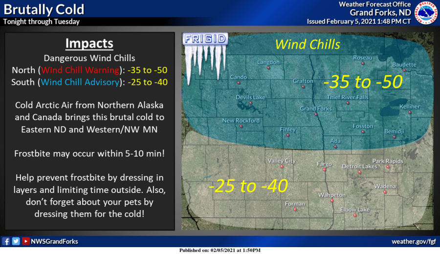
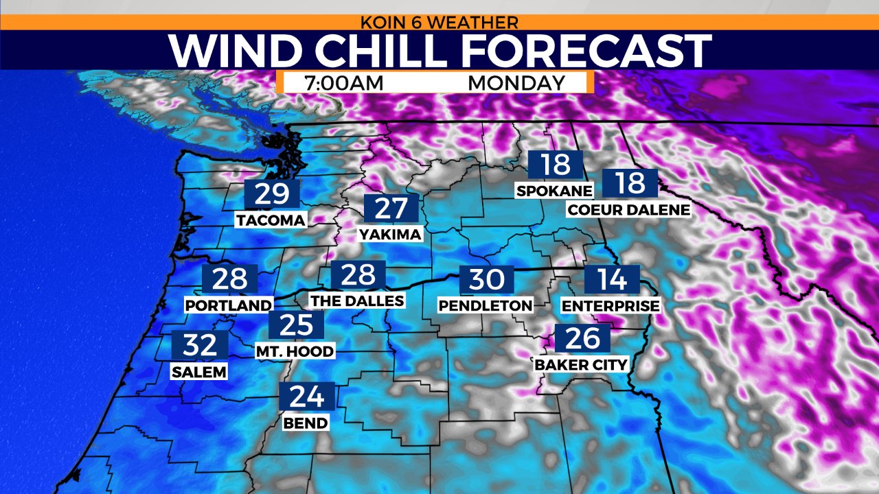
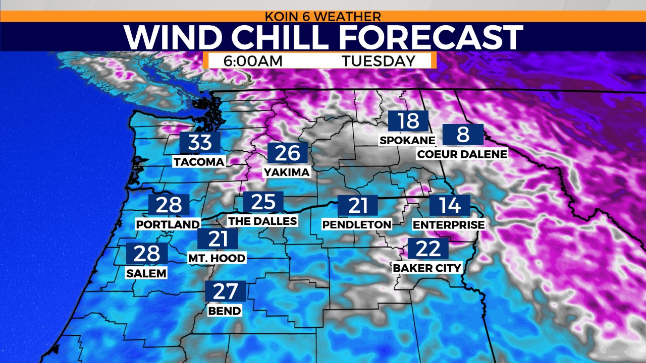
We’re west of The Rockies. How cold could it possibly be? And what about my snow?
The short answer is: you don’t have to worry about –40°F below wind chill temperatures. However, wind chill temps in the teens or 20’s are possible in our windiest locations. All the puzzle pieces are coming together for our coldest temperatures of the season, and possibly valley snow.
This week, a modified version of that Arctic air will filter over The Rockies and settle into the Columbia Basin. As pressure differences increase, the likelihood of a stronger easterly wind also increases. Will the Cascades block that cold air? Not when you have an open boulevard like the Columbia River Gorge cutting right through the mountains.
There is still much to be resolved in our suite of forecast models, so don’t go emptying store shelves. First, we must understand why this Arctic air has traveled thousands of miles out of bounds.
What is a Polar Vortex?
The polar vortex is not a monster, nor a storm with a cute winter name. Simply put, it’s an area of low pressure, a counter-clockwise circulating mass of very cold air that lives at the poles. For my science pals, don’t worry, I’ll get into the difference between the tropospheric polar vortex and stratospheric polar vortex.
For those of us living in the northern hemisphere, it’s winter and the polar vortex is doing what it does best – dancing around the north pole. Sometimes though, as we’re seeing right now, that vortex of cold air and the jet stream around it get bumped by movements in the atmosphere. And when that happens, it’s time to call your travel agent because that subzero air just got a one-way ticket to paradise.
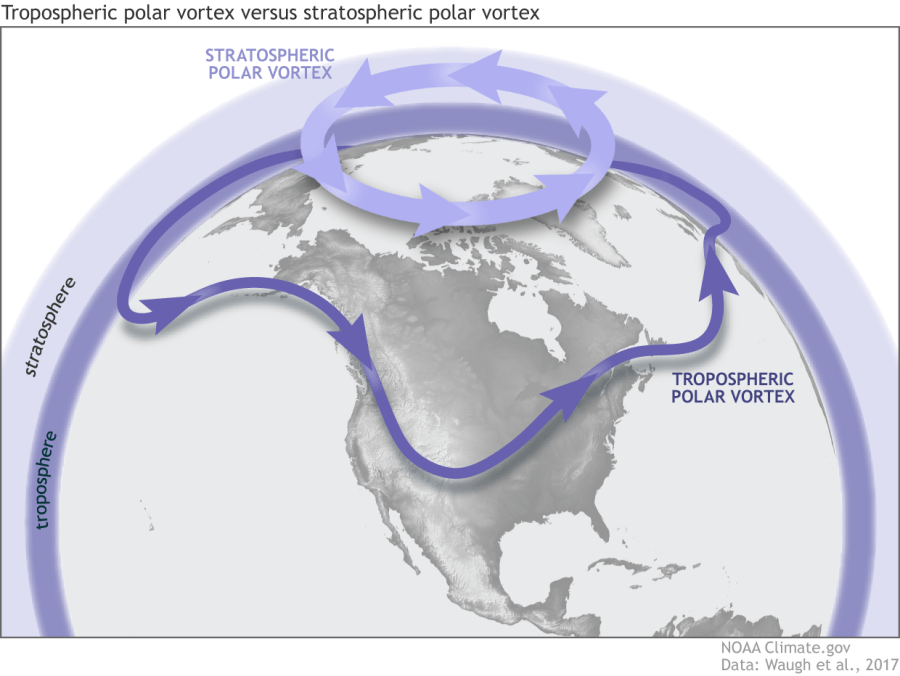
It’s important to note that while the term polar vortex is often used as a singular noun, there are actually polar vortices. Let’s start at the bottom.
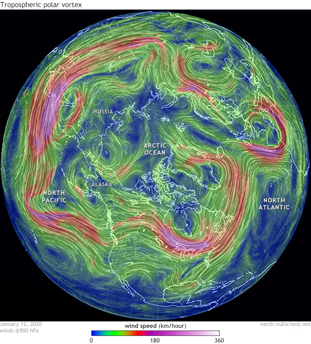
Tropospheric Polar Vortex
The polar vortex at the lowest levels of the atmosphere, the troposphere, is like that sitcom character Norm Peterson in Cheers – sitting at the bar “where everybody knows your name”, year-round.
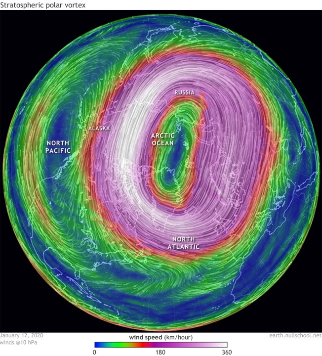
Stratospheric Polar Vortex
Then you have the seasonal bar fly, the stratospheric polar vortex, which only appears in the winter. Hence the name, this polar vortex resides in the stratosphere, about five to 30 miles up. This part is key. Stay with me here and we’ll go higher into the stratosphere with Dr. Elizabeth Austin, founder of WeatherExtreme, who explains sudden stratospheric warming in the video below.
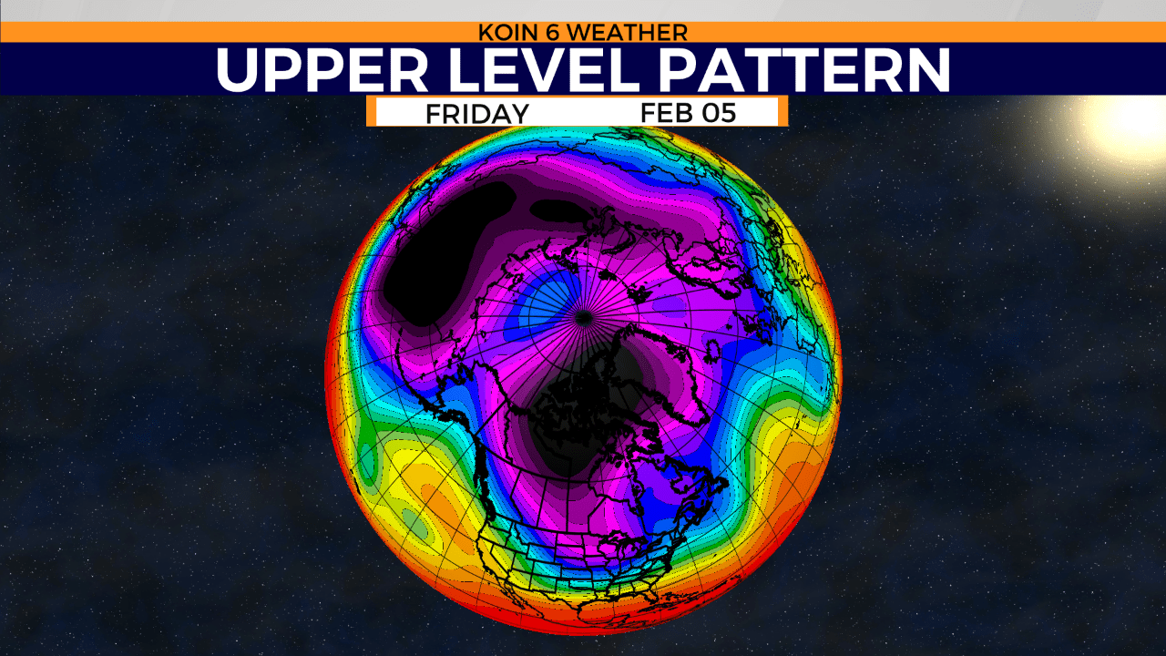
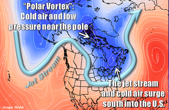
Take a look at this image courtesy of NOAA.gov. Notice the arrows. This shows you the motion of the jet stream.
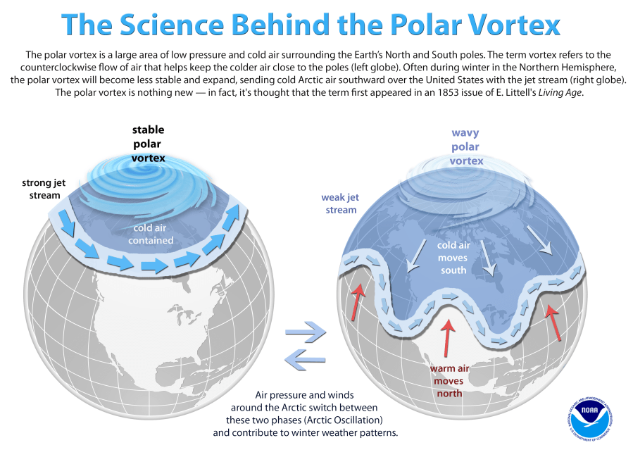
The polar vortex is considered stable, when there is a strong jet stream around it. And by strong, I mean super-fast wind, faster than a Nascar driver but slower than a passenger jet. What happens when that super-fast jet stream slows down? Well, that loosens the belt around the polar vortex. What happens when you loosen your belt? Your pants are free to roam, right? Same idea with the polar vortex.
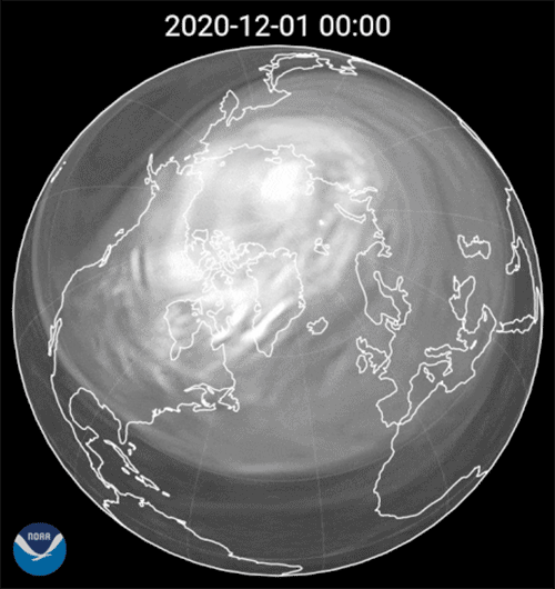
The jet stream is still there, but it meanders and looks more like a figure eight than a circle. Here’s a great example from NOAA.
“This swirling image of the polar vortex was made possible by data from several different polar-orbiting satellites between Dec. 3, 2020 and Jan. 16, 2021.” Credit: NOAA
When the jet stream weakens, subzero air leaks from the polar vortex and heads south into the mid-latitudes, where most of us live.
Who’s the troublemaker in the atmosphere?
It would be great to point to just one thing but truly it’s a combination of many factors: planetary waves, known as Rossby Waves, pressure and temperature differences, seasonal sea surface temperatures, and various oscillations to name a few.
To forecast when the polar vortex will breach its boundaries, we look up high to the stratosphere for clues.
The polar night jet is the stratosphere’s jet stream over the poles, and it’s temporary. It races around the north pole in the dark of winter, when it’s facing away from the sun. Hence, the word night. Hats off to the folks who live without sunlight for 163 day out of the year. Brrrr.
Why do we care about the stratosphere and the polar night jet? We don’t live there!
Ever heard the slogan, “What happens in Vegas, stays in Vegas”? Well, the opposite is true for the stratosphere. What happens in the stratosphere does not stay in the stratosphere.
Changes in stratospheric temperatures have a ripple effect throughout the atmosphere, all the way down to the earth’s surface. Ever heard of Sudden Stratospheric Warming? NOAA Climate Prediction Center provides us with a definition of SSWs.
“ Sudden Stratospheric Warmings (SSWs) are occasions in the winter (~6 times per decade), when the polar stratosphere warms and the winds that normally flow from west to east around the pole weaken dramatically and even reverse direction, corresponding to a breakdown of the polar vortex.
These SSWs can eventually cause the tropospheric jet stream to weaken, which allows cold air bottled up near the polar cap to escape and expand into the middle latitudes, such as the United States, Europe, and parts of Asia. The impacts on the surface are not guaranteed and they are not necessarily experienced everywhere.”
Credit: https://www.climate.gov/news-features/blogs/enso/sudden-stratospheric-warming-and-polar-vortex-early-2021
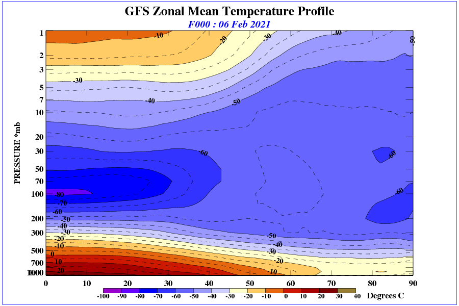
Here’s an example from the Climate Prediction Center:
Sudden Stratospheric Warming Monitoring
Enter the stratospheric classroom:
Watch the video below!
To better understand what’s happening in the stratosphere, I turn it over to Dr. Elizabeth Austin, CEO and founder of WeatherExtreme. Elizabeth monitors and forecasts stratospheric activity as the chief scientist for Perlan Project, an Oregon-based aeronautical exploration and atmospheric science research not-for-profit organization.
“In the northern hemisphere the sudden stratospheric warming is much more common than in the southern hemisphere. This is due to the vast amount of landmass in the northern hemisphere as compared to the southern hemisphere and thus temperature contrasts between the land and ocean. We have high and low pressure systems and the jet stream meanders around these and we have these large-scale planetary waves, called Rossby waves. When these get strong they can penetrate well up into the stratosphere, up to 160,000 or 165,000 feet and they break up there. When they break, they weaken the westerly flow of the polar night jet and then it can either weaken the jet or it can even turn the flow easterly.
Then when the next set of Rossby waves come through and they are strong enough to penetrate up to high altitudes in the stratosphere they reach that easterly flow and a little lower down in the atmosphere and they break there and turn the flow easterly. This keeps happening so that the waves break lower and lower down causing a reversal of flow of the polar night jet to where it has a complete reversal of flow in the stratosphere. This weakening of the polar night jet turns the air at the pole inward where it then sinks and when it sinks it compresses.
So the sudden stratospheric warming is not really a warming as such but a compression of air that causes the increase in temperature. But then as this cold air sinks at the poles and heads towards the surface of the earth it has nowhere to go and it spreads out and all of that cold air has to go somewhere. For example, right now we have the two split lobes of the polar vortex, the sister lobes, the high pressure part is over Alaska right now and the low pressure is over Greenland. This means the cold air flow between the two is coming right down into the Midwest.”
Dr. Elizabeth Austin, CEO and founder of WeatherExtreme, chief scientist Perlan Project