PORTLAND, Ore. (KOIN) — After a rare three-year run, NOAA’s Climate Prediction Center officially declared La Niña over last week.
The La Niña weather pattern, which shifts the Pacific jet stream north, bringing added precipitation and cooler temperatures to much of the Pacific Northwest, is now considered to be in an “ENSO neutral” state. This means that no La Niña or El Niño weather pattern is present in the Pacific Ocean.
Oregon state climatologist Larry O’Neill told KOIN 6 News that no immediate weather impacts are expected as a result of the shift. That’s because the effects of these patterns are typically most noticeable between November and March, he added. However, warmer, drier weather is a historically common outcome for the Pacific Northwest during an ENSO neutral or El Niño season.
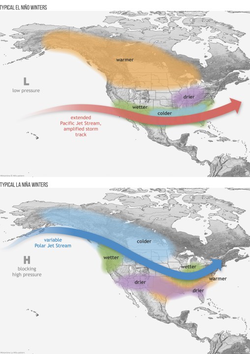
“Since 1970, of the 31 years that were ENSO neutral or El Nino, only 12 years were at or above average precipitation in Portland,” O’Neill said. “However, the last three years in Oregon have been below to well-below average in precipitation despite being in various intensities of La Niña. Climate change and global warming have also made La Niña’s warmer than they used to be, historically.”
O’Neill said that the typically dry weather pattern could exacerbate Oregon’s ongoing drought problems. He also said that there’s a chance the upcoming weather pattern brings unexpected results, so there’s really no way of knowing what’s going to happen at this time.
“Continued drought in much of Oregon is one outcome supported by analysis of historical conditions,” he said. “However, it is by no means certain that this ENSO-neutral or an El Niño period will behave like previous periods. It should be emphasized that the La Niña episode during the last three years was not typical of historical La Nina’s for much of the state.”
National Weather Service Hydrologist Andy Bryant told KOIN 6 News that it’s notably difficult to predict what the ensuing winter season will look like during the spring months. As a result, Oregonians will have to wait to see what these conditions will do for the state’s drought.
“There are indications of either ENSO-neutral or El Niño,” Bryant said. “However, the winter predictability during the preceding spring is notoriously poor. So, I think ‘wait and see’ is the best approach.”