PORTLAND, Ore. (KOIN) – Let’s be forthright straight off the bat… the chances for snow in Portland next week are minute. Election Day is likely just cold and showery.
It is true that we are expecting a cold blast. That colder air is going to help with building our mountain snow for the region. Which will be helpful after the atmospheric river Friday melts away the base.
What does that mean for the Portland metro area? There may be a brief window where temperatures are trying to get close to freezing in the Willamette Valley. The likelihood of putting it all together for snow seems unlikely.
PERSPECTIVE: WHEN DO WE GET SNOW?
Let’s start with some perspective and then we will discuss the weather forecast for early next week. There are two recorded observations of a trace of snow over at the Portland Airport, both happening on Nov. 3. Those events occurred in 1973 and 1948. The first measurable snow greater than 0.1 inches on record happened on November 11, 1955. The average first snow date for the airport usually happens in December. With that knowledge, we have seen snowflakes on the valley floor this early in the season. It just doesn’t happen often, and it takes a mighty good effort from Mother Nature.

THE DETAILS: WHAT’S HAPPENING IN THE PACIFIC NORTHWEST FORECAST?
A digging trough will drop over the PNW come early next week. This is going to open the door for cold continental air out of Canada. You will notice that the cold air drops through the Columbia Basin and into the channels of the Cascades. This is going to be cold enough to support a steady stream of snow for the mountains down to 1,500′. This is the coldest air that we have seen so far this fall. This is the type of air that we want to help build snowfall for the ski resorts.

Before we tap into that cold air, we will have a mild to relatively warm air mass on Friday. This is when the atmospheric river comes driving in and drops buckets of water over the PNW. At this time, the snow at the base of the mountains will get wiped out. If you check out the snow level forecast below, you will see the massive jump Friday, but then it starts to again drop as we get to Saturday night. This will begin the snowy trend for the mountains!

LOW ELEVATION THOUGHTS
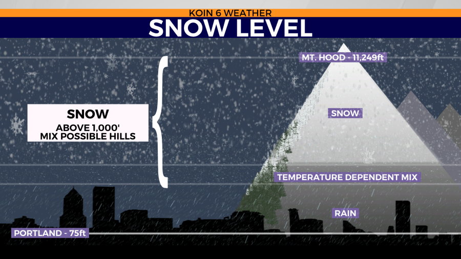
Come Tuesday morning, weather data is pushing for snow levels as low as possibly 1,000 feet. This should lead to cold showers around the Willamette Valley. Of course, this is low enough to produce snow around Sandy. We will not be discussing snow totals outside of the Cascades at this moment. Below is a general idea of the transition from snow to low-elevation rain.
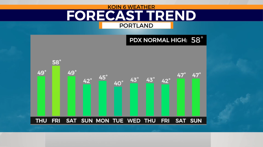
Check out the forecast trend for the coming days. Friday will be the warmest day, with daytime highs pushing 60 degrees. I wouldn’t be surprised if we jump into the lower 60s for the day. Most events that bring in the hefty rain end up being a bit warmer than models projected. Watch early next week, as temperatures seem to crash to the lower 40s. All eyes are on Tuesday morning. This is when temperatures will be most vulnerable for winter weather.
THE MOUNTAINS
Let’s wrap this up with a celebration of mountain snow. Significant snow is expected across the mountain ranges in the PNW. We are expecting FEET of snow from Saturday through midweek of next week. This is going to be a winter blast for the ski resorts. If you focus your attention on the graphic below, you will notice that hole over the Willamette Valley.

If you were crossing your fingers for an early start or at least a strong start to the season, we may be in luck this winter. The trend is calling for cold air with plenty of mountain snow after Friday!