This article is no longer being updated. Please visit our Tracking the Tropics page for the latest updates.
TAMPA, Fla. (WFLA) — After barreling through southwest Florida and battering Tampa Bay with strong winds and heavy rains on Wednesday, Ian weakened overnight and became a tropical storm Thursday morning.
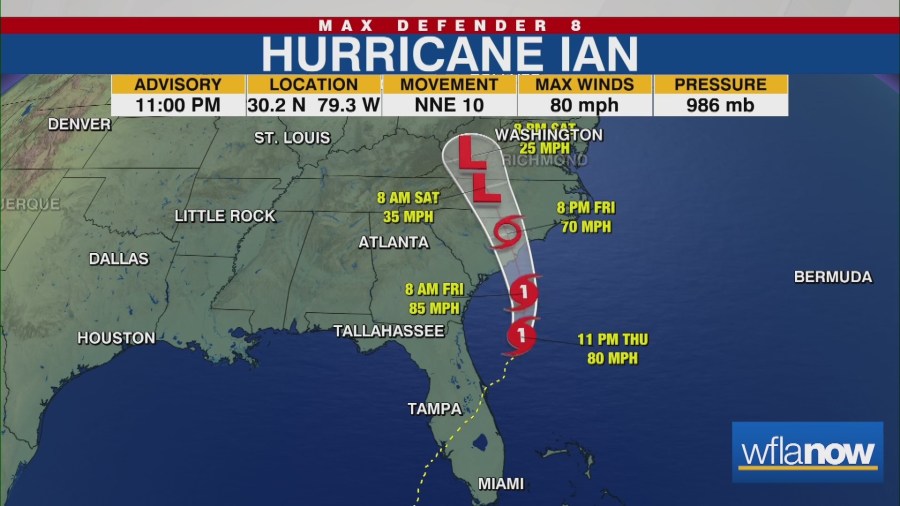
By Thursday evening, the storm regained hurricane strength ahead of a Friday South Carolina landfall.
The storm made landfall near Cayo Costa, Florida just after 3 p.m. ET Wednesday as a powerful Category 4 hurricane with maximum sustained winds of 150 mph.
By 11 p.m. Thursday, the storm had maximum sustained winds of 80 mph and was about 185 miles south of Charleston, South Carolina. It was moving north-northeast at 10 mph.
“Ian is moving back over the ocean, and this time the very warm Gulf Stream, so it will likely intensify some more before landfall,” meteorologist Jeff Berardelli said. “Luckily, there is some wind shear to limit intensification.”

Although the storm has lost much of its strength, it is still producing catastrophic flooding over east-Central Florida, and will likely continue to produce strong winds, heavy rains, and storm surges across portions of Florida, Georgia, and the Carolinas.
“The impacts will still be significant,” Berardelli said. “Up to 7 feet of surge is expected. And as much as 8 inches of rain, which will cause flooding because this part of the Carolinas is prone to flooding and has a recent history of significant flooding events.”
Swells from the storm are affecting Florida and could cause life-threatening surf and rip current conditions. The storm could dump another 2 to 4 inches of rain on portions of East Central and Northeast Florida.
Parts of Florida remain under a storm surge warning, meaning the storm could raise water levels above normal tides.
According to the NHC, water could reach the following heights above ground in the following areas:
- Edisto Beach to South Santee River (4 to 7 feet)
- Murrells Inlet to Cape Fear (3-5 feet)
- Cape Fear River (2-4 feet)
- St. Johns River (2 to 4 feet)
- East of Cape Fear to Duck, including Pamlico and Neuse Rivers (2-4 feet)
- Patrick Air Force Base to Flagler/Volusia County Line (1 to 3 feet)
- Albemarle Sound (1 to 2 feet)
Here is a list of watches and warnings that are in effect as of 8 p.m. ET Thursday.
A Storm Surge Warning is in effect for:
- Flagler/Volusia Line to Cape Fear
- Neuse River
- St. Johns River
A Hurricane Warning is in effect for:
- Savannah River to Cape Fear
A Tropical Storm Warning is in effect for:
- Flagler/Volusia County Line to Savannah River
- Cape Fear to Duck North Carolina
- Pamlico Sound
A Storm Surge Watch is in effect for:
- North of Cape Fear to Duck North Carolina
- Pamlico River
- Cape Fear River
A Hurricane Watch is in effect for:
- East of Cape Fear to Surf City
Tracking Hurricane Ian
>> Latest updates on Hurricane Ian
>> Max Defender 8 Hurricane Guide
>> Download the Max Defender 8 app