PORTLAND, Ore. (KOIN) – The cold spell of spring continues to hypnotize the Pacific Northwest.
The conditions have been beneficial across the board for both Washington and Oregon, but it’s surely a cool spring. The cool weather means rain and snow, but as the spring wheel continues to bring the same weather back to Portland, the weather has shifted to more of a summer return across other areas of the United States.
How are we missing out on that heat? Doesn’t the weather usually move from west to east?


Temperatures are jumping into the 90s across the Midwest, with heat indices brushing over the triple-digits. This is the type of heat that you cross in the summer. A cut-off area of low pressure has parked itself just east of Florida. This is pumping the wind counter-clockwise, keeping the east coast right in the sweet spot for some nice weather.
What’s causing all the heat? There is a strong southerly flow ripping through the belly of the US. That wind is relatively strong and it is pumping in warm air from the south. It’s also pumping in that moisture from the Gulf of Mexico. That has increased the humidity from Louisiana to Wisconsin.
The weather pattern graphic shows just how deep the trough is cutting through the Great Basin. That is keeping conditions cooler and wet from Washington south to nearly Las Vegas. Temperatures are warmer in Bismarck, North Dakota than in Las Vegas, Nevada today. That sharp contrast between cold air and warm is helping aid to that strong wind that is slicing through the midsection of the United States.
Because of this particular setup, unseasonal weather is taking over areas of the US. It’s the cut-off low east of Florida and the deep trough from the PNW that is squeezing that warm air up north. This is not your traditional ridge that forms on the west coast and progresses east, impacting all in sequence.

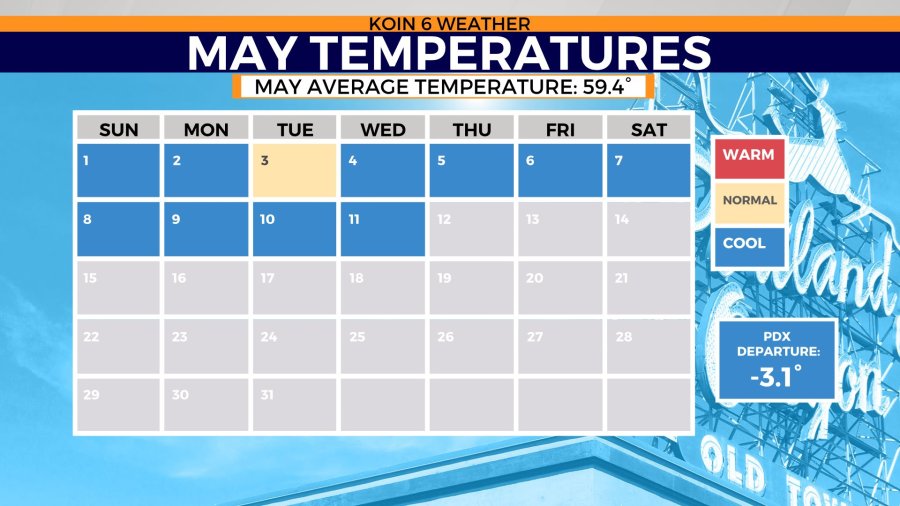
We are a week and a half through the month and we have 10 days below average and one day that hit the average on the nose. Temperatures are nowhere close to the 90s in Portland. We aren’t even close to the 80s. We can keep on going… we aren’t even close to the 70s (this week).
There will be some counterbalance closer to the weekend, but we aren’t moving towards any heat. Right now, Portland is at a -3.1 departure from the normal. Our afternoon temperatures have been cold AND our morning temperatures have been cold.
The combination of the two leads to the outcome that you see in the May calendar below.

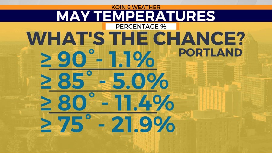
What’s the actual percentage for temperatures in the 70s? What if we were on the other side of the coin and were seeing warmer than average weather? To answer the first question, Portland generally sees temperatures above 70 degrees in May 36.9 percent of the time.
This month, we have had days that were nearly 15 degrees below average. If we were 15 degrees ABOVE average, we would be closer to 85 degrees. That happens about five percent of the time in May. That type of temperature departure can be powerful. You can see a chart below of some of the milestone percentages for warmer weather.
The chance for temperatures above 90 degrees is just about one percent. That is the type of heat that these locations well up near the Great Lakes are experiencing. That is why they are breaking records! We will keep an eye out for our first spell of heat.