PORTLAND, Ore. (KOIN) – We love a good bluebird day up in the mountains of Oregon, but too many may be more of a problem than a benefit.
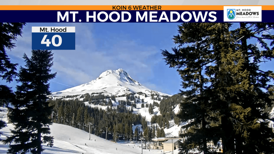
Right now we have a stale setup, which is going to keep conditions dry and even warm. Temperatures have been hitting the lower 50s at the base of Mt. Hood Meadows, while daytime highs only have hit the 30s and 40s for the Willamette Valley and Portland itself.
This is because of the sharp temperature inversion that we have over the region due to a persistent high pressure, which you can learn more about the temperature inversion here.
There is still a strong base up on the mountain to enjoy but we have to keep an eye on the situation at hand. We are looking deeper into the forecast for snow, which may not be around for the next five days. This may lead to an additional 5 to 10 inches of snow loss over the next week if we keep everything the same.
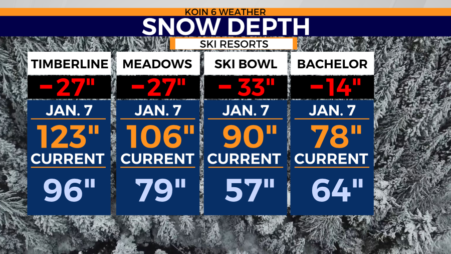
Let’s rewind back to Jan. 7, 2022, which was near the tail end of our massive stretch of snowstorms. Both Timberline and Mt. Hood Meadows were clocking in over 100 inches of snow at that date. From that point on, we’ve only had a few isolated snow events. Overall, the snow depth has been shaved a good 14 to 33 inches depending on the ski resort. All three ski resorts on Mt. Hood have seen snow loss since early January. Ski Bowl has had the most significant snow loss, with the elevation a bit lower than the other two ski resorts. It would take two or three snow events to catch up to the loss that we’ve had since Jan. 7. That is completely possible if we find another atmospheric river or curtain of cold air coming down from the north. We know that isn’t in the forecast right now.
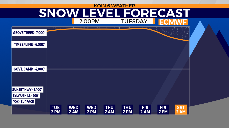
If you check out the snow level forecast, the snow level is way up there above Timberline Lodge until Saturday. Even then, there are no signs of a blast of cold air coming our way for the remainder of the month. February can be a busy month up on the mountain and we are looking forward to another blast of winter. It is a La Niña winter!
For those of you who frequent Mt. Bachelor, they didn’t have the same explosion of snow early in the month to calculate such a drastic change. All of the ski resorts that we track have come in the negative. That doesn’t mean the base isn’t still good to go for skiing. We have plenty of snow up there to keep the season chugging at full speed.
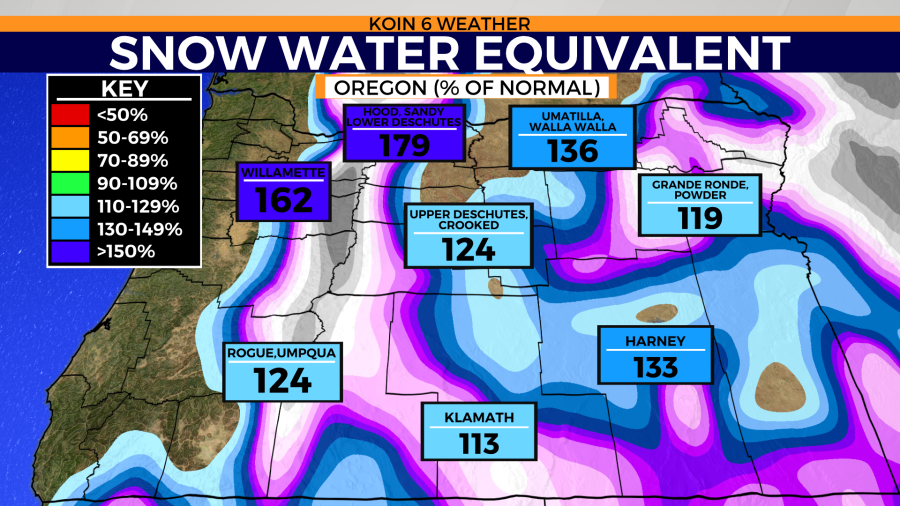
The current snow water equivalent (SWE) is still in the green and blue for most locations. We are at 130% from the 1991-2020 normal, with the Malheur region dropping down to 82%. We can afford more bluebird days up on the slopes, but if you’re looking for fresh powder, it’s not coming this week. We are fortunate that areas around Mt. Hood are doing extremely well for late January.
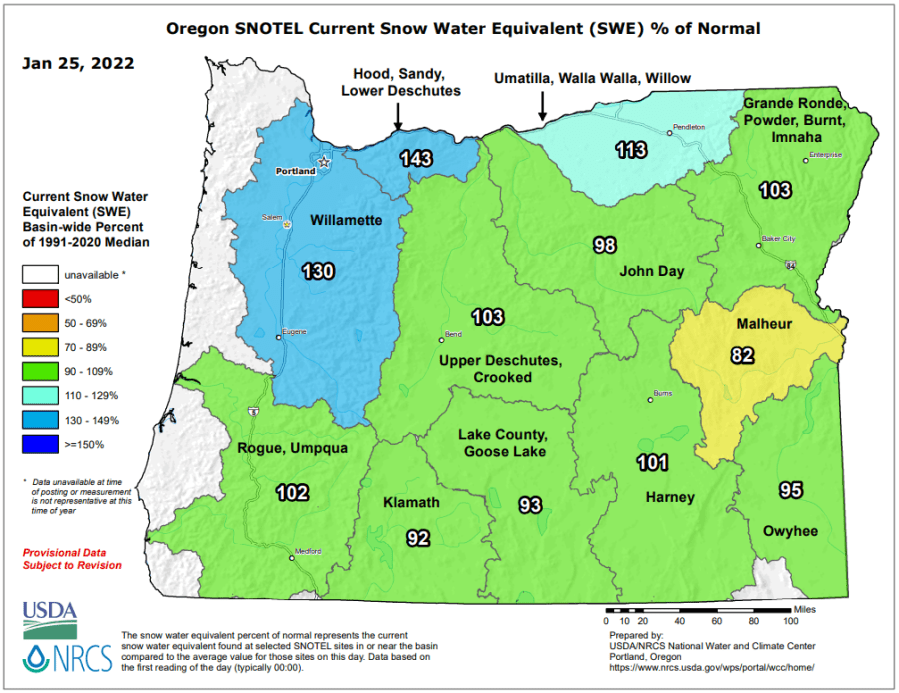
It did look like this two weeks ago. Can you see the changes that have occurred over this very quiet pattern? Although we are still successful this winter, many areas are now down 10 to 20 percent from the January 7 period of time.
We want to continue to build the mountains up and we want to quit the whittling process that has been coming at our snow for the last few weeks. All eyes on early February for that swing in temperatures.