PORTLAND, Ore. (KOIN) – As October comes to a close, the upcoming winter season starts to creep into the mind. The questions start flying, “Should I buy a ski pass this season?” or “Will we get snow in Portland this winter?”
The quick answer to the latter is that we do not know this early in the year. Forecast models that can reliably predict snowfall amounts, months ahead of time, simply do not exist.
However, we are at a point in the year where oceanic and atmospheric patterns are giving signals for winter season activity. There are methods of analyzing these complex signals to help provide a credible winter outlook, even if the snow is still a few months away. Most long-range seasonal forecasts are built using a combination of these cues and weather trends over previous decades.
To form my winter outlook this year, I took a dive into seasonal trends over the last 100 years in Portland. Here are my thoughts.
El Niño Southern Oscillation (ENSO). What is it and why does it matter?
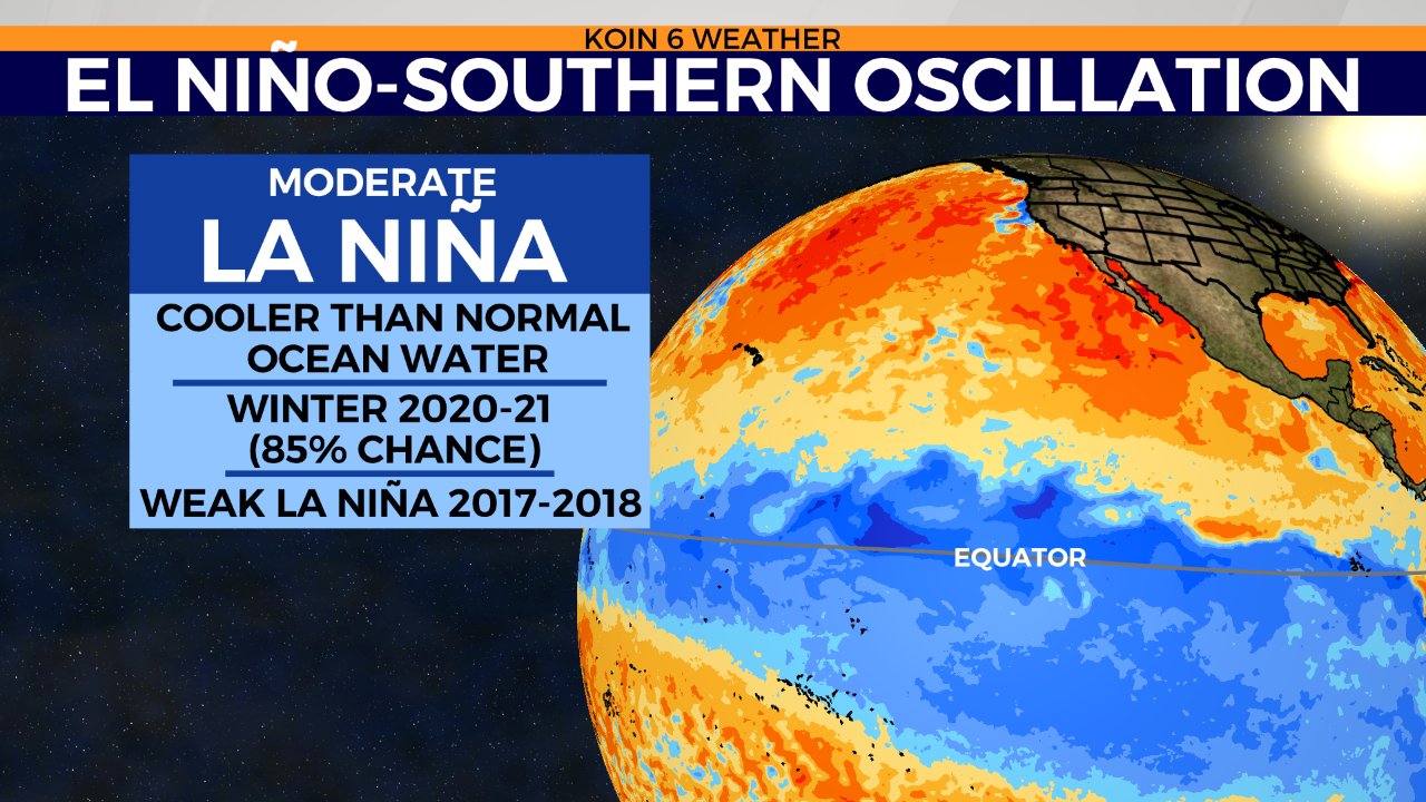
The first spot to look for winter weather cues is over the Pacific Ocean. Researchers have continued to track sea-surface temperatures along the tropical equator since the 1950s. The shifting body of warmer or colder than normal water is called the El Niño Southern Oscillation (ENSO). It can play a major role on influencing our winter weather in the Northern Hemisphere. For more in depth details on ENSO, click here.
Current observations of cooling sea-surface temperatures along the equator show a moderate La Niña pattern is on the way this winter.
Good news for those seeking snow days and crafting snowmen, right? Think again. La Niña winters tend to provide cooler and wetter weather across the Pacific Northwest, but that’s not always the case for snowfall here in Portland.
Tracking Previous La Niña Winters
To get a better hint about snowfall in Portland this winter, I spent some time looking at previous La Niña patterns since the 1960s. Take a look at seasonal snowfall in Portland over the last 40 years, since 1980.
Notice first that there were two major snow storms in the 2017-2018 and 2008-2009 La Niña episodes (blue dots).
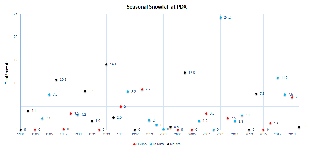
What’s also notable is the period of light seasonal snowfall during La Niña winters between 1999 and 2016. Almost every winter during that time brought around 3 inches or less of snow to the city. That’s well below the normal snow totals for the winter season! So the idea that heavy snowfall in the city comes during a La Nina is somewhat untrue or a common misconception.
La Niña snowfall odds also favor (at PDX):
- 35% chance for 7 inches or more
- 40% chance of normal snowfall amounts or more
- 55% chance of under 3 inches
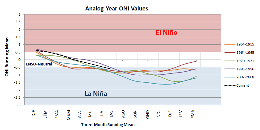
I also took a closer look at five specific La Niña winters for more hints this winter. I call this set my analog years, since they most closely resemble our current ENSO pattern based off of our current Oceanic Nino Index (ONI).
An ONI index of -0.5 to -0.9 shows a weak La Niña, -1.0 to -1.4 is moderate, and -1.5 to -1.9 is a strong event.
You can see how the current index (dotted black line) has a very similar trajectory to my analog years.
Stacking my set of analog years with La Niña winters in general and the climate norms show some interesting results.
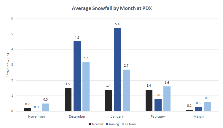
On average, the analog years showed above-normal snowfall in December and January. This could mean an active start to the winter season and perhaps a few snow events on the way.
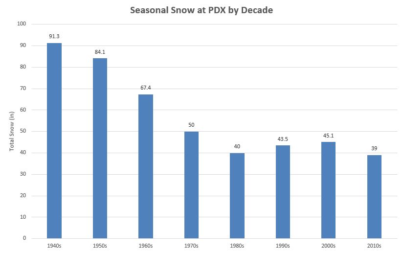
The data also shows above-normal snowfall per month for all La Niña winters since the 1950s (light blue bars). However, there’s a caveat. Significantly more snow used to fall in Portland before the 1980s, when seasonal snowfall averages were closer to 7 to 9 inches of snow during the winters. For our last four decades (1980s to now), total snowfall in Portland has leveled out to around 40 inches per decade, or around 4.6 inches on average per year/season.
Lowland Snow Outlook
This year is a bit of a toss up. La Niña winters have provided relatively light snow seasons in Portland, but also two of the last five major snow storms since 1980.
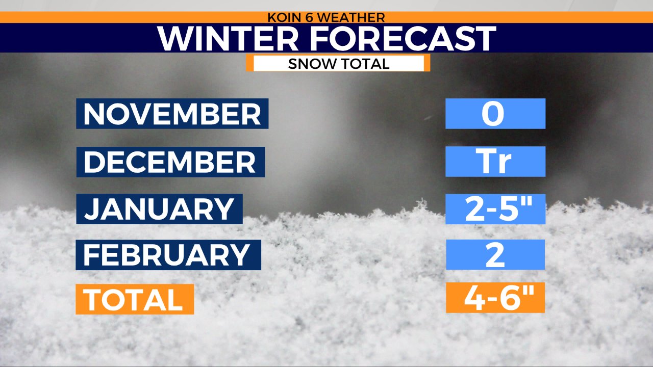
I believe we will run on the lighter to average side of snow this season with near-normal totals. However, I’m betting we see one to two snow events this season that drop 2 to 3 inches of snow. I also think it’s less likely, but still possible, that we get to see one larger snow even that brings maybe 5 inches of snow to Portland. I think it’s most likely we get any of those events in January or beyond. I don’t believe we’ll see a major snow event, dropping 7 or more inches of snow, at any point this winter.
Here is my official forecast — or let’s call this a ”wishcast” — for snow in Portland (at PDX) this year. Again, take this with a grain of salt. It is just for fun. There is no way to know how much snow we’ll see in a month this far in advance.
What about ski season?
As for this upcoming ski season, there is some great news for those ready for the slopes.
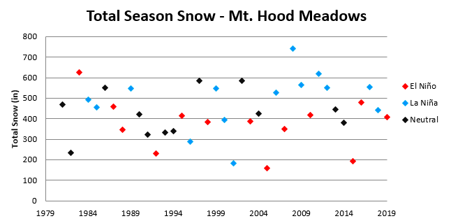
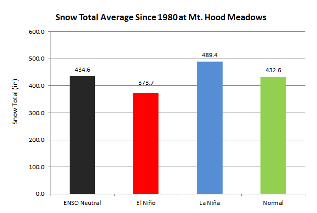
La Niña winter years have historically given above-normal snowfall throughout the winter seasons. Data provided by Mt. Hood Meadows shows seasonal snowfall since 1980 with average yearly snowfall around 430 inches above 5,000 feet. Notice how the past seven La Niña seasons have provided above-normal snow in the Cascades.
The odds are in favor of a fine snow season!
Rainfall & the Water Year
Portland is coming off of a major drought year where 93% of the state is still in some level of drought and a whopping 39% of the state is experiencing extreme drought (as of Oct. 27, 2020).
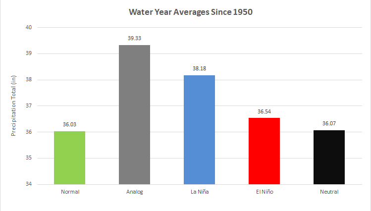
On average, Portland receives 36.03 inches of rain throughout the year. Last year, (Oct. 1, 2019 through Sept. 30, 2020) we received 27.98 inches of rain, about 8.05 inches below the normal amount.
With our La Niña winter in store, odds are in favor for a wetter-than-normal season and above-normal rainfall in Portland. I have high hopes that this winter brings much relief to the PNW and an end to our state-wide drought.
My Final Thoughts
As we move into our snowier months, take any extended snow forecast with a grain of salt. We really don’t have much certainty on snow amounts more than two to three days out. Be sure to follow the entire KOIN 6 Weather Team as we await the upcoming winter season and bring you updates on channel 6 and social media.