PORTLAND, Ore. (KOIN) – Have you ever walked out the door and turned right back in for a heavier jacket?
“WHOA IT IS COLD OUT HERE…WHERE IS MY WINTER JACKET!?”
You may be asking how the morning is so much colder on Thursday than it was on Wednesday? Well, there are a handful of factors that could be swaying the morning temperatures, but we can definitely break down what those factors may be. In fact, now is a great time to do it, because this time of the year can bring in some cold mornings and at times, mild ones.
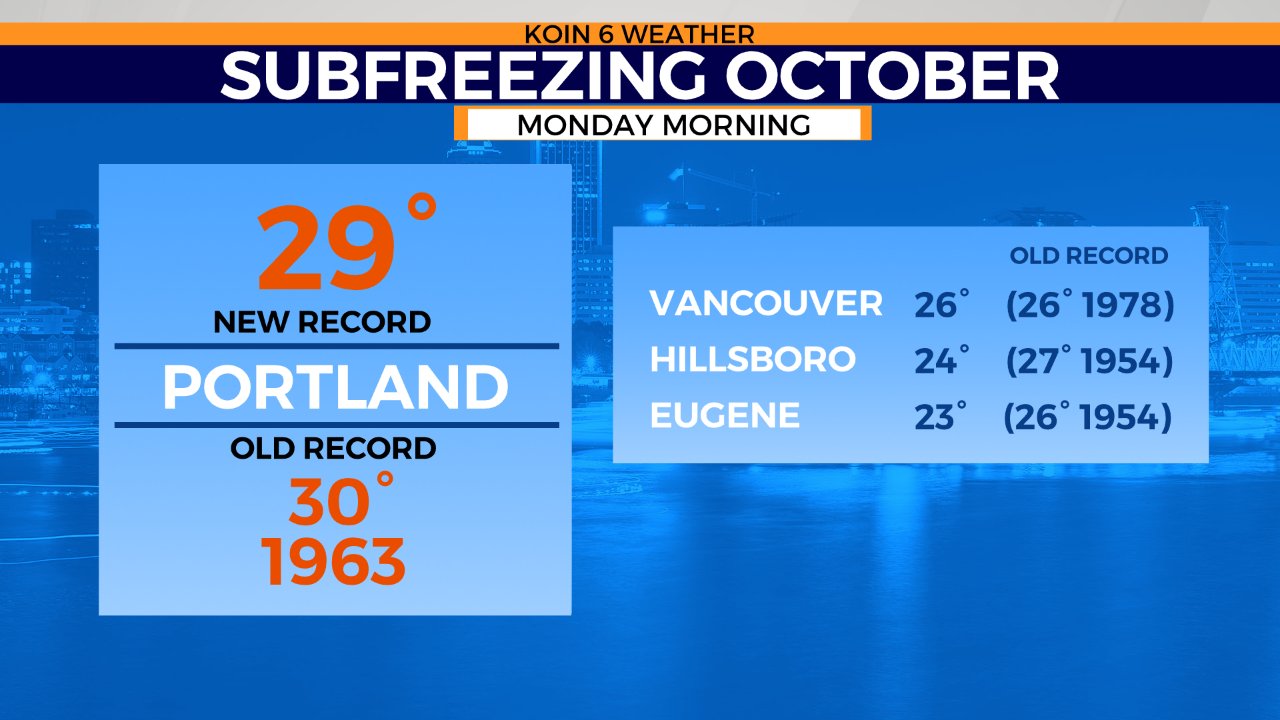
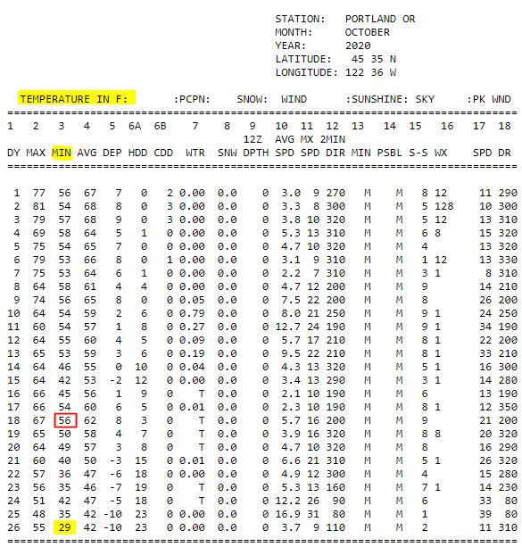
Let’s take a look at the month of October 2020 with the observation chart from the National Weather Service in Portland, Oregon. A comparison from the morning of October 18 to October 26 is found below. One morning came in with a low of 56 and the other a record low of 29 degrees. In about the span of a week, we had a morning low in the mid 50s and one all the way down to the upper 20s. What is the deal with that? Then in between, we have many other morning temperatures in the 40s. How do we end up with one warmer and the other cold?
Well it is true that we may have larger scale impacts going on in these scenarios, but there are also a lot of factors that can be taken into consideration when determining a cold vs mild night/morning. Why morning? Well most of the time, the low temperature of the day is right before the sunrise in the early morning hours.
WHAT’S GOING ON?
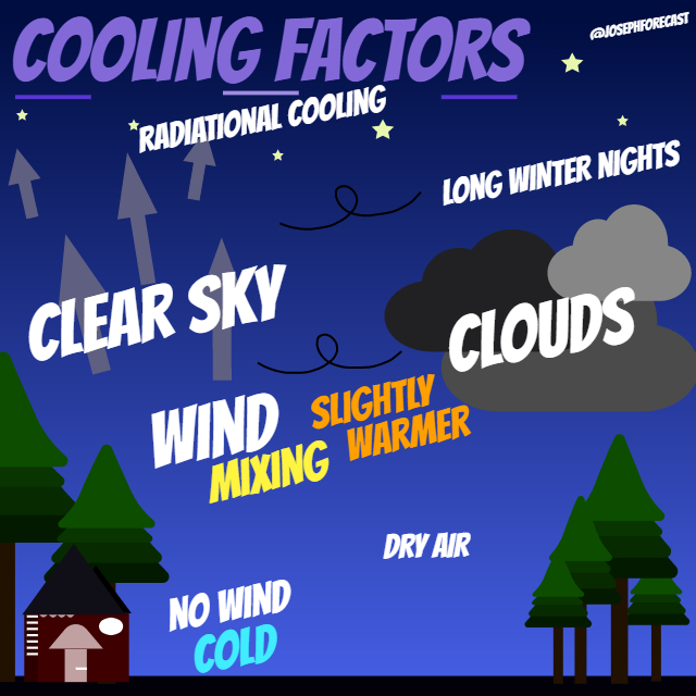
At night, the earth’s surface cools by radiating the heat that we gathered from the sun off to space. That is what we will refer to as radiational cooling. It is near the surface where the cooling is the strongest and higher in the atmosphere it tends to be warmer. As the night hours come in, conditions tend to be more stable because of the lack of sun and heat. This is prime time for conditions to settle down and for cooling to occur.
Below, gives an idea of the general cooling factors that influence our overnight and morning temperatures.
- Wind
- Cloud Cover
- Dry Air
- Long Winter Nights
What about these factors influences our temperature?
Let’s start with wind. We know that the wind can usher in warmer and cooler air. This is a major influence on our temperatures. At night, when the wind calms down, this is when we can actually find our coldest mornings. Why? As discussed above, warmer air aloft can find a way to the surface if there is enough of a wind to help mix the atmosphere. When the wind is calm, that allows for the surface to reach it’s potential or bottom out. Over the night of October 25 to the morning of October 26, in Portland, the wind went from blustery to calm. This kept any warm air from finding a way to the surface.
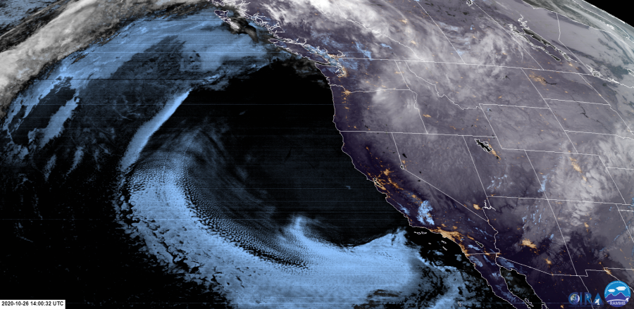
Cloud cover was just about non existent on the morning of October 26 , 2020. You may hear that a layer of clouds acts like a blanket for us at night. That is true, because that heat that is trying to escape overnight, will find a way to either be trapped or essentially come back because of the clouds above. During the day, those clouds will prevent the heat from coming in. At night, the clouds help aid to a warmer surface. The satellite image below is from the morning of October 26, 2020. A mostly clear night for the Willamette Valley was taking place. This was allowing maximum departure of heat.
This particular night, was also very dry. The dew point was low and that means there was less water vapor. With less water vapor in the air, that longwave radiation was able to fully emit out to the atmosphere. Water vapor tends to absorb that longwave radiation and that may restrict the ability for temperatures to drop as much as if it was dry.
Lastly, we are starting to see longer nights. You know, the daylength coming in at like 10 hours or so as we get closer and closer to winter. That means we have plenty of time for that heat to continue to escape and that will generally cool us down more than a night that was shorter in the summer.
When you’re forecasting, these are things that you’re taking into consideration. The weather models may say something like 40 degrees, but then you have to understand, all the other conditions that are in play for the night. Portland, Oregon, broke the record of 30 degrees back from 1963 on October 26. It was the combination of all those things above and uncommon winter air moving in early from Canada on this day. If for some reason the clouds moved in or the wind stayed strong, we likely would have been cold, but not record breaking cold.