Editor’s note: We’re still tracking this potential winter storm, with much of the region under a Winter Storm Watch. Click here for a full list of weather alerts and click here for the latest story.
PORTLAND, Ore. (KOIN) – We are now entering the window of time where we will be shaping our forecast for a potential upcoming snow event. Information will be pouring in the next two days and as you know, a snowstorm in Portland is never cut-and-dry.
Why don’t we start with what we do know and what remains a constant? Cold air is going to be moving in through the next few days and it will settle in for the Columbia Basin by Thursday morning. We’re talking about temperatures in the single digits and teens in northern Washington and down to the 20s for many around the Tri-Cities and down into Oregon. Any moisture that spills over the Cascades will lead to snow.
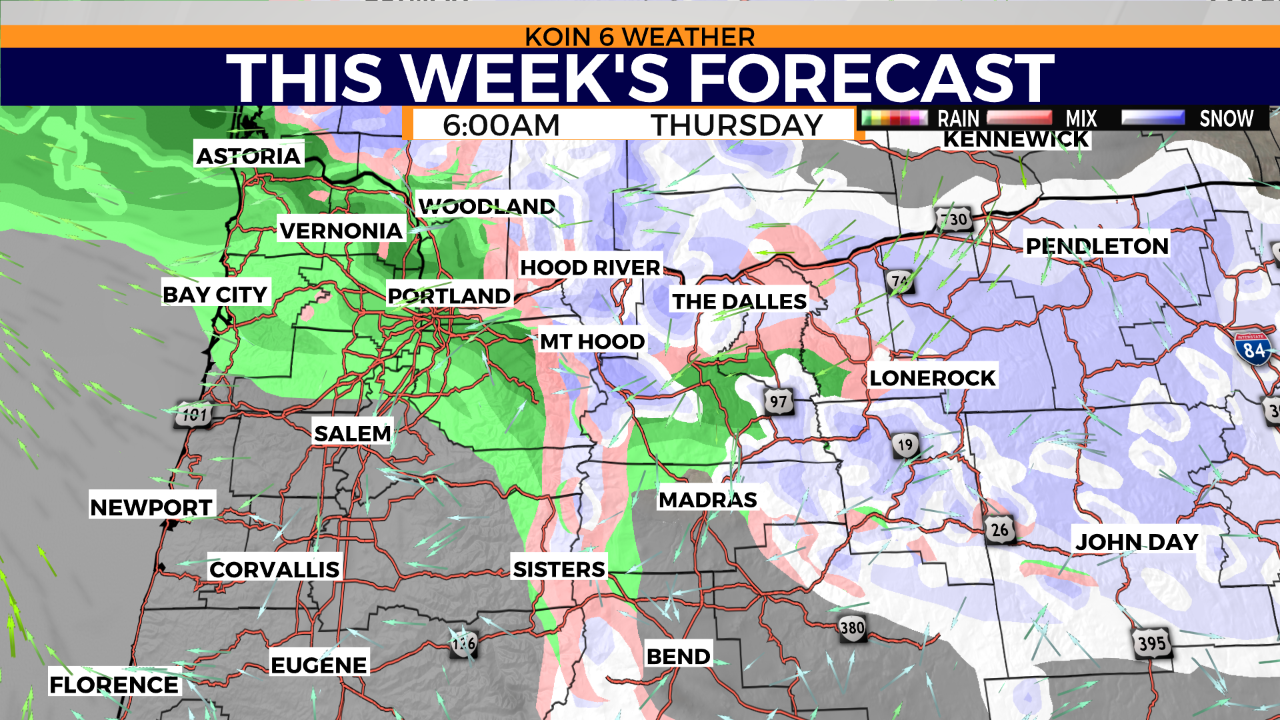
We will freeze the forecast at 6 a.m. on Thursday morning, where weather models are already producing some moisture around the region. This will ultimately be lighter compared to what may arrive later in the day. Expect snow to start as early as the morning for the mountains and points east. You may notice that the precipitation is coming in as rain around Portland and to the south.
This is likely the case if we do see moisture in the morning. The full effect of the Gorge wind doesn’t look to kick in just yet, but it will be increasing through the day. The timing of this precipitation is likely to change by tomorrow. This is one area of the forecast that will improve.
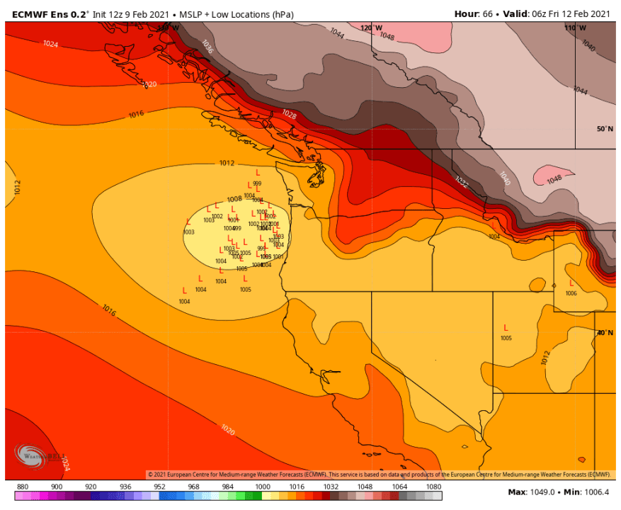
Another ongoing question, where will the area of low pressure land? We will call that the weather maker, which is what we will be tracking heading into Thursday. Like most winter events in Oregon, this is one of the key factors for us.
Why does it matter? Depending on the location of that low, the wind will be a major factor. The farther north it travels, the more vulnerable we are to warmer air coming in from the south. If it settles around the central coast, we are likely to have colder air reaching the Portland area and surrounding communities. Ultimately, if you want snow, you do not want that low to travel any farther north. However, check out an ensemble of all the potential locations this low may end up. There are some outliers, but the consensus is coming together in that general area from Astoria down to Coos Bay.
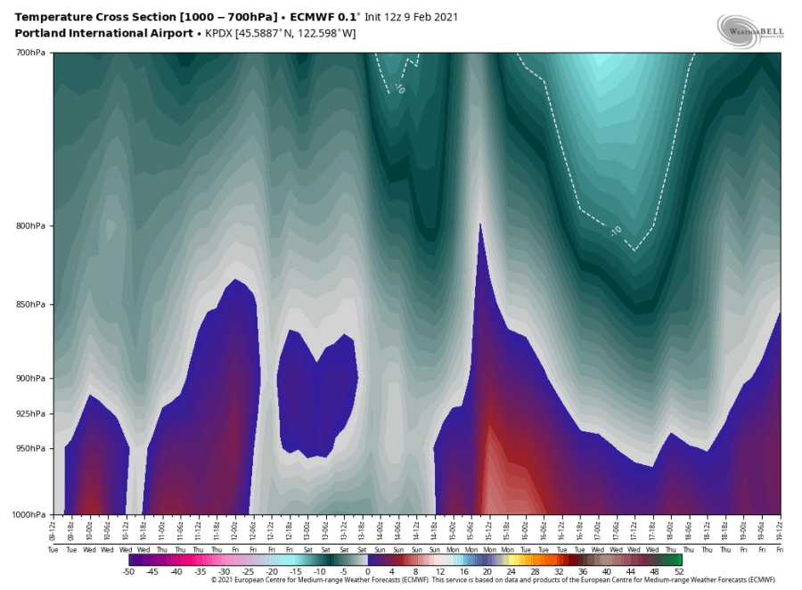
We are also watching out for a wintry mix of precipitation around the valley Thursday into Friday. The image below is a cross-section of the temperature at the airport through the coming days. We notice spots that may be at freezing near the surface but pockets of warmer air aloft that could turn out to be a freezing rain scenario. This is strongest south of Portland in portions of the valley that are closer to Wilsonville and Newberg. That could lead to ice and a dangerous situation for travel. We know that ice events can be treacherous. This cross-section keeps temperatures above freezing for a majority of Thursday until around 7 to 10 p.m.
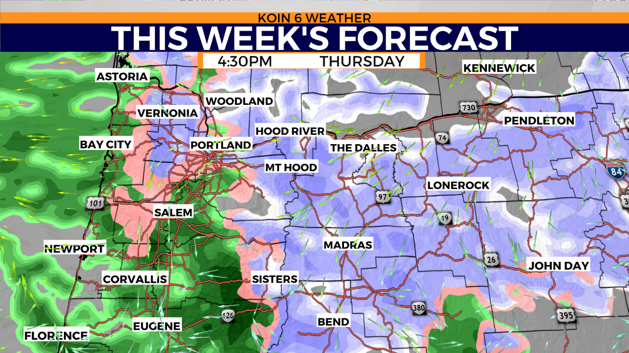
Knowing the information above, you can see how the forecast come Thursday afternoon is a mix of rain, freezing rain and snow. That warmer layer of air seems to extend up the Willamette Valley to the north and then collides with that cold air coming out of the Gorge. You may remember the winter event a few years ago where the east side of the river had snow and those to the west didn’t see anything. We may have a close call like that again with this event. Right now, Portland is still in the window for snow, especially later in the day Thursday and through the overnight into Friday.
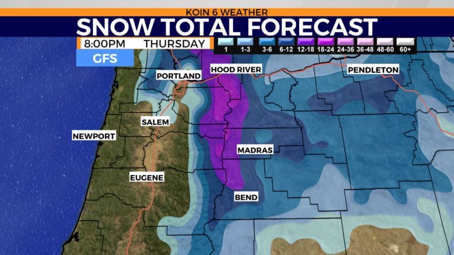
Speaking of snow, you can see the two different major weather models as of 8 p.m. Thursday night. One brings heavier snow in for the mountains and Gorge. Also, providing some light totals in part of the valley. The second, keeping us slightly drier and out of the snow until after 8 p.m..

By Friday morning temperatures are likely in the 20s for most. The moisture will lighten up on Friday, but I believe there is a shot that most folks can catch some snow. Unless that area of low pressure continues to track farther north, that cold air should have a good chance to reach most.

That takes us to our next concern, and that will be the system that arrives on Saturday. Temperatures likely to be the coldest we’ve seen all season with highs not even topping off in the 30s for many spots. If this is the case, any sort of moisture that moves in will bring snow for many.
What will warm us up? A strong southerly wind can bring back some mild air. That doesn’t look to be in the forecast this weekend. We will see if that changes in the coming days. Right now we continue to focus on Thursday and that possible transition from rain to snow.