PORTLAND, Ore. (KOIN) – Summer keeps on giving, but Sunday we get one of the “cooler” days so far this season.
A dip in the jet stream will allow for a small pocket of cooler air to move through on Sunday. This should limit temperatures to the 70s for most communities, even east of the Cascades. Although I would say that lower 80s is probably more realistic, especially the farther south you go.
Regardless, this is going to be a nice day. So nice, you should really take advantage of it, because we have plenty of the warm summer days coming. We may be back to the triple-digits by midweek.
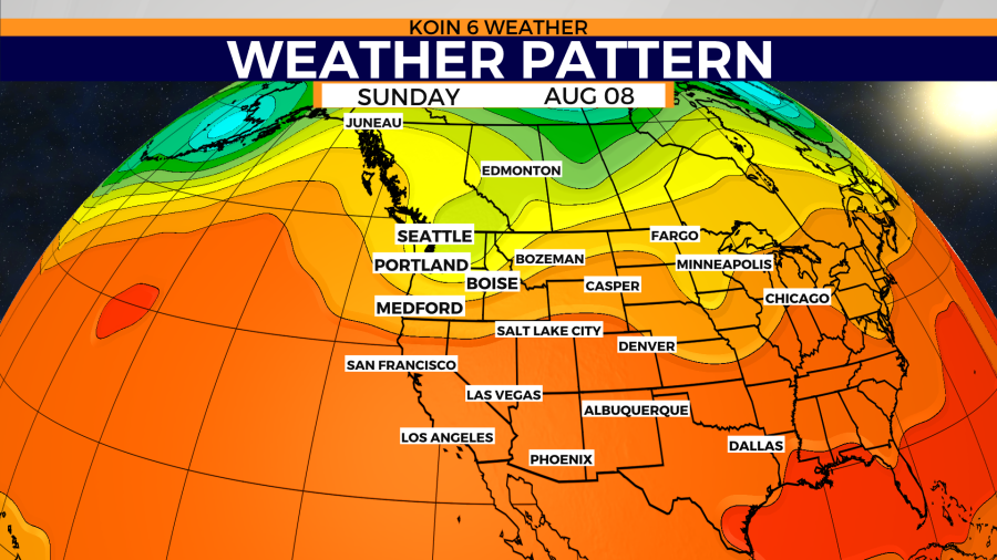
If you consult the weather graphic below, you will notice that area of yellow and green protruding south into Washington and Oregon. That is the area of low pressure that is responsible for our batch of cooler air that is going to inhibit temperatures Sunday (forecast below). It only hangs out for a day, before it is out of here. This may mean some clouds and a few areas that are dealing with isolated showers in Sunday morning.
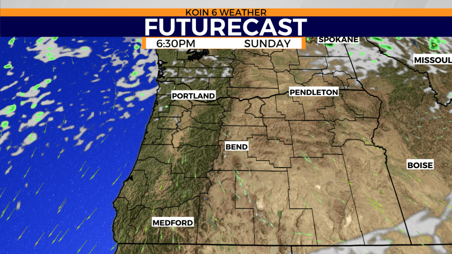
The futurecast is supporting a few isolated showers around Cowlitz County and even into Clark County. The flow aloft may also push some showers over the Cascades. A leading edge of this trough is also seen slashing across the the state into areas of central Oregon and Idaho in the morning. There will be some clouds and showers developing as that disturbance travels through.
Behind that, we start to dry out Sunday afternoon. This is when we will see mostly sunshine and not nearly as much cloud coverage. Gear up for a nice sunset around here with a pleasant Sunday evening unfolding. Passing clouds for the northwest Oregon coast, but most other locations should be starting to clear out.

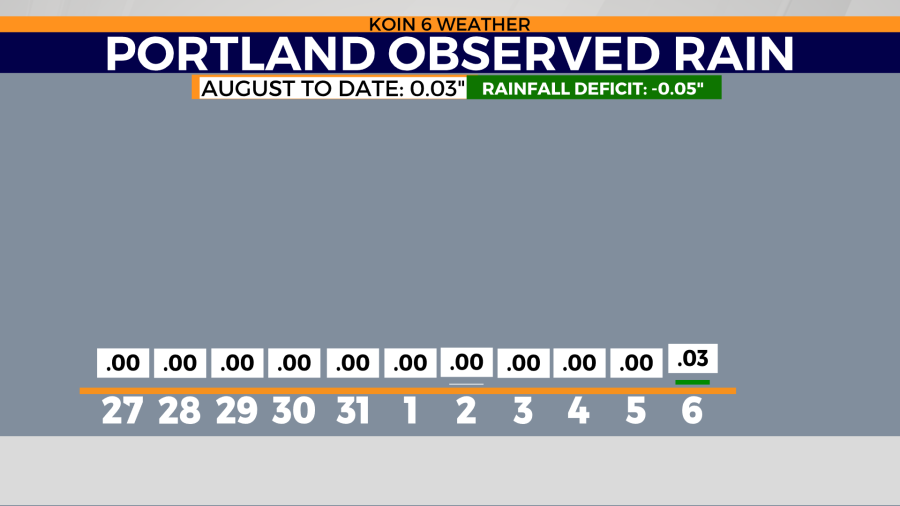
Will we get some rain overnight into our morning? There is a small chance for a few isolated showers early Sunday morning. I mentioned the threat more so in Cowlitz and Clark counties, but even across the Columbia River into Portland is possible. We had our first measurable rain in 51 days on Friday and we may luck out with another small measurement Sunday morning. I would plan on a mainly dry day today.
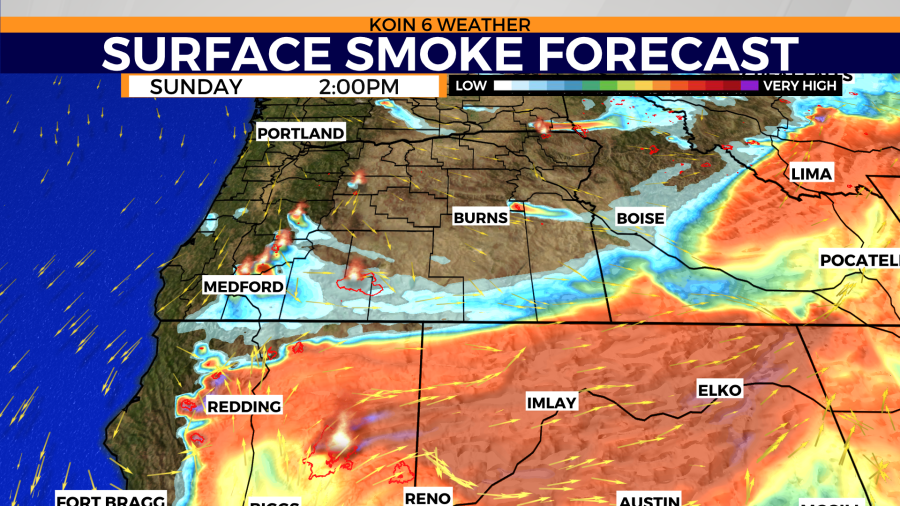
How about smoke? There won’t be much outside of the local wildfires that are burning around Washington and Oregon. Because of the increase in relative humidity and the path of the wind, we will have minimal smoke on Sunday. That is another reason for the overall superb conditions Sunday in the state of Oregon. The surface smoke forecast has a few plumes extracting, but those wildfires won’t be nearly as active as they have been in the recent past. Thick smoke for California and Nevada on Sunday.
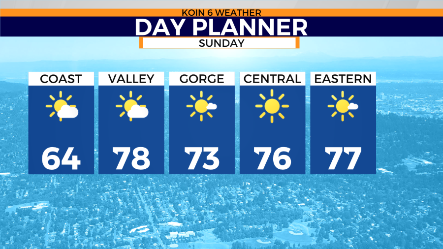
Alright, here is the temperature forecast for Sunday afternoon. Pick your spot and enjoy it.
Temperatures in the mid 60s for the Oregon coast. You will start off cooler in the 50s and then it will pick up as you get into the afternoon. Most locations on Sunday will be in the 70s, with some isolated spots in the 80s. As I mentioned above, it will be warmer to the south. The closer you get to Eugene, the warmer the temperature will be. Areas down south in Medford will be in the upper 80s.