PORTLAND, Ore. (KOIN) — For anyone who needs to hear this: we are 131 days from the Winter Solstice! Ok, back to your blazing hot forecast.
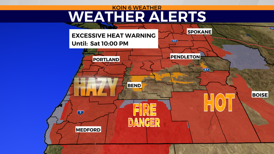
Here’s Friday in a nutshell: hot with daytime highs up to 100+ again and hazy skies with moderate air quality for Portland. The Columbia River Gorge, eastern WA and all locales close to wildfires will be stuck with mostly unhealthy air today.
For the weekend, expect temperatures in the mid-90s with improving air quality, visibility, and general temperature relief.
Excessive heat warnings are still in effect in addition to red flag warnings and air quality alerts.
Crunching the heat in hundreds

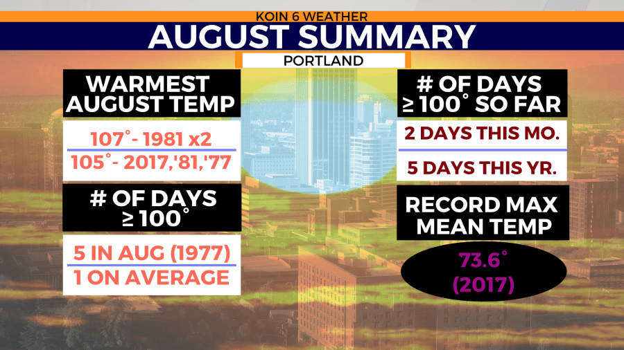
For the fifth day this year, Portland reached a temperature of at least 100 degrees on Thursday. Being that we are Portland and not Port Las Vegas, this is not normal.
On average Portland sees one 100-degree day per year. Portland has not had more than five days of 100-degree temperatures in one year, according to Portland Airport records provided by the National Weather Service. I’m not talking five days in a row, I’m talking five days at any point during the year. As of this morning, Portland has reached this milestone record only three times: this year, 1977 (all 5 days of which were in August), and 1941 (all 5 days of which occurred in July).
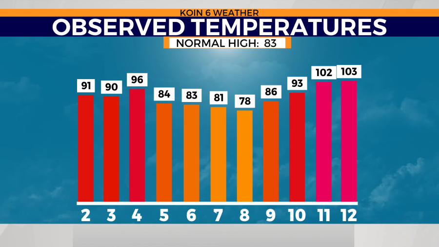
Portland’s high temp recorded at PDX Thursday was 103. This number fell short of breaking the daily record of 104. No one is disappointed.
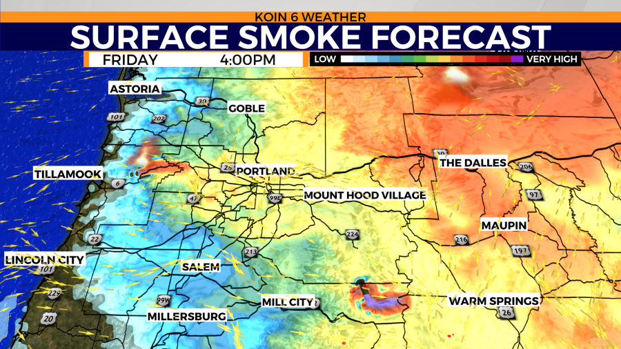
Our heating potential was arrested due in part to wildfire smoke. Even though the smoke wasn’t thick enough to block out the sun for days like the Labor Day fires of 2020, it was the combination of winds aloft and surface winds that dragged in wildfire smoke from hundreds of thousands of acres burning to the north and south, making this unfortunate sandwich of particulate matter. The outcome is a range of air quality from moderate to very unhealthy across the state.
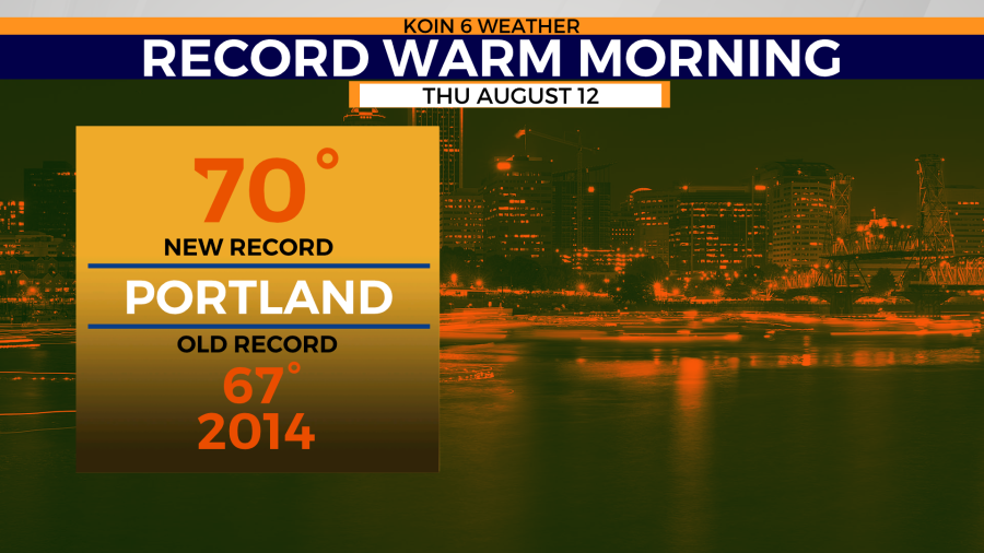
Portland also broke a max low record Thursday morning and will likely do so again this morning. Thursday’s low was 70. The old record was 67 in 2014. In these predawn hours, PDX was still teetering on 80, so I’m going to bet my ice cream that we don’t dip below 66 today (daily max low record for 8/13 last set in 2016).

Remainder of Thursday’s broken records:
Eugene 104 (102 – 1977), Vancouver 103 (102 – 1992), Redmond 101 (100 – 1977), Olympia 96 (tie 1977), NWS Seattle 93 (tie 1977), Hoquiam 88 (84 – 1977), and a major milestone for Bellingham WA: first 100 on record for any month (85 on this date 1956, all-time max 99 set June 28 of this year).

Air quality and smoke forecast:
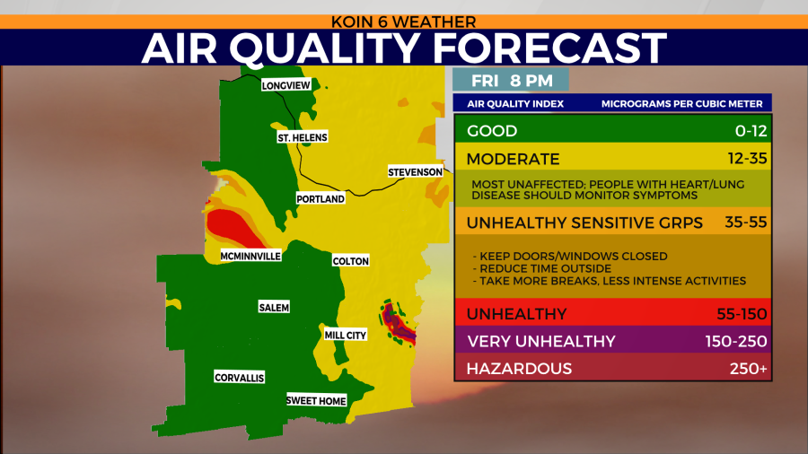
AIR QUALITY ADVISORY IN EFFECT THROUGH FRIDAY AFTERNOON
Lane and Linn counties: Eugene, Florence, Oakridge, Willamette Pass, Albany, Lebanon, and Sweet Home
The Oregon Department of Environmental Quality, and the Lane Regional Air Protection Agency have issued an Air Quality Advisory, which is in effect through Friday afternoon around eastern Lane County and southeast Linn County. Wildfires burning in the region combined with forecasted conditions will cause air quality to reach unhealthy levels at times through Friday afternoon.
May see improvement during the late afternoons and evenings for the next several days. When air quality improves to good or moderate on the Air Quality Index, open windows to air out homes and businesses. Smoke levels can change rapidly depending on weather. Please visit the Oregon Smoke Information Blog for current conditions. Pollutants in smoke can cause burning eyes, runny nose, aggravate heart and lung diseases, and aggravate other serious health problems. Limit outdoor activities and keep children indoors if it is smoky. Please follow medical advice if you have a heart or lung condition.
https://forecast.weather.gov/wwamap/wwatxtget.php?cwa=pqr&wwa=air%20quality%20alert
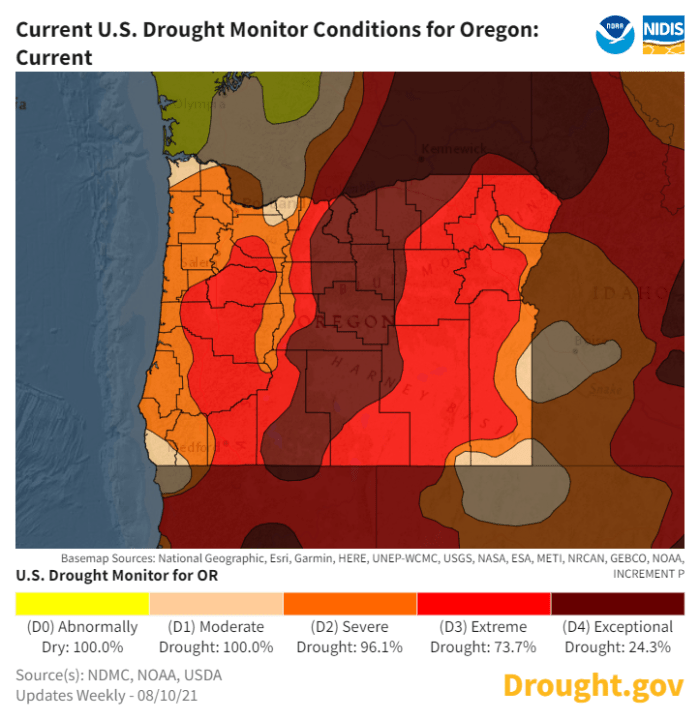
Drought status update for Oregon:
Nearly 74% of the state of Oregon is in an extreme drought. There is no significant change in drought status from last week. In other words, it’s still bad.