PORTLAND, Ore. (KOIN) – For the second winter in a row, La Niña conditions are expected to persist through February 2022 and bring impacts to precipitation and temperature across our region.
What does that mean for snow in Portland or snow in the Cascade mountains? Could we see a second winter in a row with 10.1 inches of snow in the city? If I really knew the answer to those questions, in October, I’d be rich! It’s simply too early to forecast that far out with accuracy.
However, we are at a point in the year where oceanic and atmospheric patterns can provide signals for winter season activity. There are methods of analyzing these complex signals to help provide some sort of winter outlook, even if the snow is still a few months away. Most long-range seasonal forecasts are built using a combination of these cues and weather trends over previous decades.
Every year in October, I set aside a week of my time to dive into 80 years worth of data on Portland’s winter trends. There are lots of numbers and graphs to ingest in here… but please, stick with me.
These are my thoughts for the 2021-2022 winter outlook:
Tracking Previous La Niña Winters in Portland
One of, if not, the most defining characteristic of an upcoming winter is through the lens of the El Nino Southern Oscillation (ENSO). That’s because oceanic and atmospheric circulations are coupled, often impacting each other by shifting blobs of water and air masses around. Due to persistent below-average sea surface temperatures across the eastern equatorial Pacific Ocean, La Niña conditions have emerged this winter. A La Niña pattern tends to provide cooler and wetter weather across the Pacific Northwest during wintertime as colder storms drive into the region from the north.
Let’s take a look at previous La Niña winters here in Portland. I plotted seasonal snowfall in Portland over the last 40 years, since 1981. Notice there were three significant snowstorms producing over 10 inches of snow in 2008-2009, 2016-2017, and last year’s La Niña episodes (blue dots). Neutral winters have also been known to produce hefty winter snow amounts.
Also note that the last three recent La Niña winter’s (2017, 2018, 2021) all produced above-normal snow here in Portland.
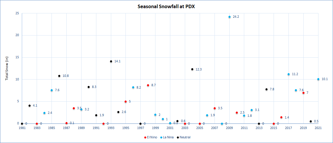
On the other hand, notice the period of light seasonal snowfall during La Niña winters between 1999 and 2012 (there were seven of them). Almost every winter during that time brought around 3 inches or less of snow to the city, which is below-normal snow for a winter season in Portland.
So what can we expect this year? Data not only suggests a chance for significant snowstorms in Portland but winters with lighter-than-normal amounts too.
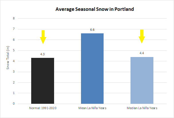
Let’s dive in further. Take a look at the graph above. On average, Portland received 4.3 inches of snow per year from 1991-2020. Average snow in all La Niña winters since the 1950s have brought in more, closer to 6.6 inches, or about 1.5 times the normal snow amount.
I wanted to remove some of our winter snow outliers, like the major 20+ inch snow years we saw in 2009 and 1956, by using the median average. This brings average snowfall in La Niña winters (since 1950) closer to what we’d normally see, around 4.3 inches.
This result suggests that significant snowstorms in the city are not all that frequent during a La Niña winter. However, for the last three La Niña winters, we’ve received nearly double and triple the normal amounts of snow over the season.
La Niña snowfall odds also favor (at PDX):
- 26% odds of 10 or more inches
- 39% odds of 7 or more inches
- 48% odds of above-normal snow amounts
- 57% odds of below-normal snow amounts
- 13% odds of trace or zero snow amounts
Second-Year La Niña trends: Could we see more snow?
There is still more to analyze here. This winter is special because it will be a back-to-back La Niña winter. Could we possibly see some impacts from that?
Let’s take a look at averages across 10 second-year La Nina winters since 1950. There is evidence that more snow tends to arrive in these patterns. In fact, data suggests we could see nearly double the amount of snow compared to normal.

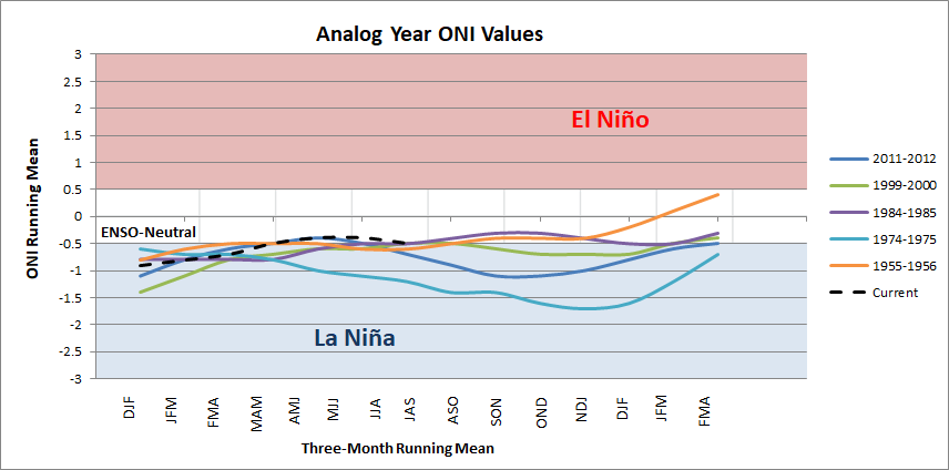
I also took a closer look at five specific La Niña winters for more hints this winter. I call this set my analog years since they most closely resemble our current ENSO pattern based on our current Oceanic Nino Index (ONI).
An ONI index of -0.5 to -0.9 shows a weak La Niña, -1.0 to -1.4 is moderate, and -1.5 to -1.9 is a strong event. This year, we are skirting along a weak La Niña pattern.
You can see how the current index (dotted black line) has a very similar trajectory to my analog years.
Stacking my set of analog years with La Niña winters in general and the climate norms (1981-2010) shows great results for snow lovers.

On average, my analog years showed snowfall arriving in November and impressive, above-normal snowfall in January. This could suggest an early start to the snow season and perhaps an active start to the new year. It continues to look like above-normal snow is in the cards this coming winter…
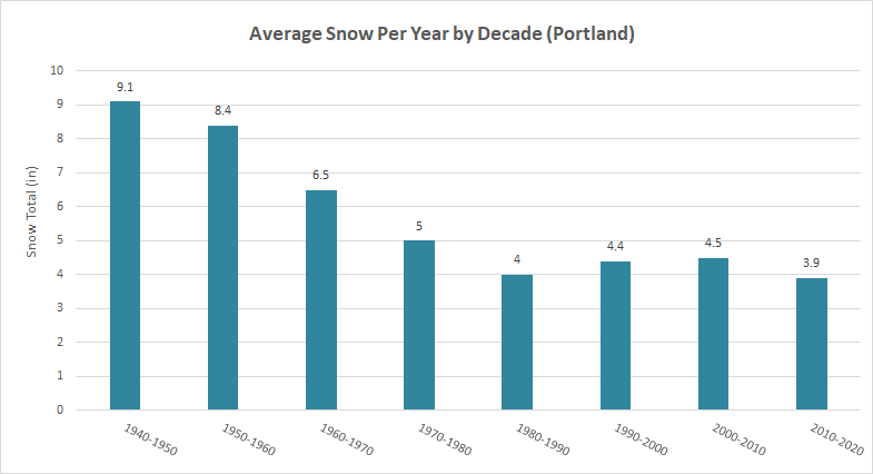
One caveat to note is that significantly more snow used to fall in Portland before the 1980s when seasonal snowfall averages were closer to 7 to 9 inches of snow during the winters. For the last four decades, from the 1980s to now, snowfall in Portland has leveled out to around 4 inches on average per season, likely due to climate change. Before 1980, Portland saw one to two more major snowstorms of 10 inches plus per decade.
Lowland Snow Outlook
La Niña winters can produce significant snowstorms in Portland, and second-year La Niña winters tend to produce double the amount of normal snow. With that, I am leaning on the snow odds that I calculated earlier.
I believe we will see measurable snow this winter, or in other words, at least one snow event that will put city operations on pause. I also think Portland could see above-normal snow this season.
I’m betting we see one light snow event before the new year that drops around 1 inch of snow, as well as a few moderate snow events after the new year that brings in 2 or more inches each of snow to Portland. I also think we could see cold conditions persisting for a while with a few snow scares all the way into March.

Remember, this prediction is going off of historical records only, not actual weather model output. In the back of my mind, I also think we are overdue for a quiet winter. So take this prediction with a grain of salt! If you are a fan of metro area snow, the odds are stacked to provide a good year for you. And if you’re not a fan, be sure to have a plan in place and keep your eyes and ears on the forecast as we head into winter.
What about Ski Season?
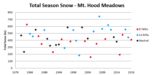
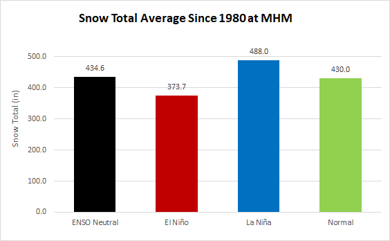
I have great news for those excited to hit the slopes. La Niña winters have historically given above-normal snowfall throughout the winter. Data provided by Mt. Hood Meadows shows seasonal snowfall since 1980 with average yearly snowfall totals around 430 inches as base (around 5,300 feet) every November through May when the resort is open for business.
Last year brought in 469” for the season. The past eight La Niña seasons have provided above-normal snow to the northern Cascades of Oregon.
If you’re on the fence about a season’s pass this year, I would pull the trigger. Now the bigger question – how early should I wake up to beat the rush to the parking lot?
Rainfall & the Water Year
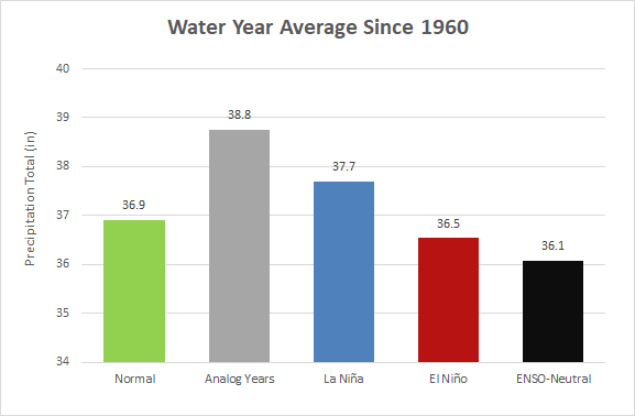
A big bonus to La Niña winters is the tendency to see above-normal precipitation around the Pacific Northwest. Our state really needs the rain too. The Oregon Climate Office stated that the Willamette Valley saw is 2nd driest 6-month period (March-August 2021) since 1895. Drought can set the stage for active wildfire seasons, which was the case both in 2020 and 2021.
Even though we have a La Niña winter in our favor, it does not automatically mean we will see a wetter than normal rainy season. We can use our most recent water year (2020-2021) as an example. However, NOAA’s Climate Prediction Center has forecast drought conditions improving and even ending through the winter season across the Pacific Northwest.

When I ran some data, my analog years brought in more rain than normal, and more rain than La Niña winters even. I have high hopes that we receive substantial rain over the next eight months and put some kind of dent into our persistent drought.
