PORTLAND, Ore. (KOIN) — El Niño. You’ve heard about it and kind of know what it is, but what you really want to know is: Are we going to have one and what will it do to the winter weather this year for the Pacific Northwest?
The short answers are: Yes, and we may have an exciting start to the winter season.
A weak El Niño is (70-75%) favored to develop, which means the Pacific Northwest could experience a range of winter conditions tied to this ENSO phase (El Niño-Southern Oscillation). Data shows that some of our snowiest winters have occurred during El Niño.
Out of the Top 10 snowiest winters in Portland, 60% occurred during an ENSO neutral phase, 20% during La Niña, and 20% during El Niño.
On the other hand, some of our driest winters have occurred during El Niño. Taking data from 20 winters in Portland that saw a trace or no snow at all, 9 were during El Niño, 8 were ENSO Neutral, and 3 were during La Niña.
Overall, the winter of 2018-19 should statistically see lower than average snowfall in the Willamette Valley — but there’s a chance for at least one snow event in the valley before the end of 2018. So you’re saying there’s a chance? I know, this doesn’t help your winter dilemma – to buy studded tires or not! The reality is, if our temperatures trend toward above average, as is typical for El Nino, then freezing levels increase, i.e., you have to go higher to find the snow.
After the first of the new year, the odds for warmer and drier weather increase, with a persistent ridge of high pressure possible.
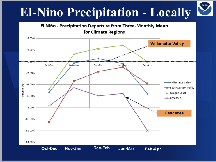
El Niño winters in the past have caused below normal snow pack in the Cascades and is something we may see going into the winter. Records show below normal normal precipitation amounts during El Niño occur most for Cascades and southern parts of the valley.

There could also be a lot of fog in the valley — caused by inversions — in January and February. There may even be offshore ridging if El Niño takes hold. Or El Niño might not fully develop and return to a neutral phase. If that happens, anything is possible.
Here’s the list of weak El Nino years based on ONI (Oceanic Nino Index). The Oceanic Niño Index (ONI) is NOAA’s beacon for monitoring El Niño and La Niña, according to Climate.gov. These are opposite phases of the climate pattern called the El Niño-Southern Oscillation, or “ENSO”. When the Oceanic Niño Index is +0.5 or higher, El Niño conditions are present according to NOAA. This indicates the east-central tropical Pacific is significantly warmer than usual.
1952-53
1953-54
1958-59
1969-70
1976-77
1977-78
1979-80
2004-05
2006-07
2014-15
Graphics Gallery: Visual predictions for El Niño 2018-19