PORTLAND, Ore. (KOIN) – The drought in parts of the Pacific Northwest is not something the region is likely to recover from any time soon, experts from Oregon, Washington and Idaho said in a media briefing Thursday.
In fact, many of the areas impacted most by drought would need 150-200% or more of normal precipitation over the next two months to lessen drought conditions, according to the National Oceanic and Atmospheric Administration.
“The odds of getting that much precipitation are considerably less than 50%, something like 1% to maybe 7%, something like that. So, the chances of catching up are really, really low,” explained Washington state climatologist Nick Bond.
According to the latest U.S. Drought Monitor report from Feb. 22, 74% of the Pacific Northwest is in drought and 19% is in extreme or exceptional drought.
Bond said if the precipitation shortcomings had only occurred within the last year, climate experts wouldn’t be as concerned.
However, prolonged drought is creating a mounting problem in the Northwest. The longer it stays dry, and the longer the state goes without a normal snowpack, the harder it is to catch up to those normal levels.
For the last two water years, from October 2019 to September 2021, Oregon has experienced its third-driest period on record, going back to 1895. This year, 2022, is starting off even drier than 2021.
“We’re going into some tough times in Oregon for the summer,” Oregon state climatologist Larry O’Neill said.
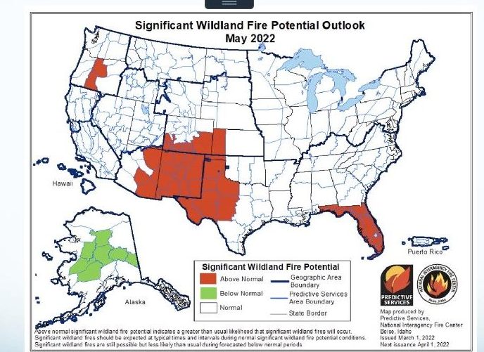
Additionally, reservoir levels in Southern and Eastern Oregon, and Southern Idaho, are at historic lows and experts are predicting above-normal potential for wildfires in Central Oregon in May.

In fall 2021, meteorologists were looking forward to another year of La Niña conditions. La Niña tends to provide cooler and wetter weather across the Pacific Northwest during wintertime as colder storms drive into the region from the north.
Unfortunately, climate experts say a high pressure ridge near the western U.S. has largely diverted precipitation away from the region over the last month and a half, meaning the La Niña storms that could have brought precipitation to parts of the Northwest didn’t have the anticipated impact.
Since those storms were diverted north, Washington has reaped some of the precipitation benefits. Karin Bumbaco, Washington’s assistant state climatologist, said Washington appears to be the “winner” in the Pacific Northwest this time around.
The state’s currently at 89% of its normal snowpack and water supplies in most of Western Washington are looking good. She said overall, snowpack and precipitation have been better in Washington the last several years compared to Oregon and Southern Idaho.
When it comes to the concern about the potential for wildfires in Central Oregon in May, Eric Wise from the Northwest Interagency Coordination Center said they’re mostly concerned about human-caused fires. He said things like burn piles could spread and get out of hand.
They aren’t expecting many naturally-occurring fires in May.
After the heat dome that occurred in June 2021, where temperatures climbed to 116 degrees in Portland, many people fear another heat event like this could occur in the near future.
However, experts say they still don’t expect heat domes to become regular events. Bond said they can’t be predicted very far out, but he expects the region will only see them once every five to 10 years.
“I would be astonished if we had anything of that severity this year,” he said.
O’Neill chimed in saying what people can expect to see are more consecutive days where the high temperature remains above 90 degrees Fahrenheit. In 2021, Portland tied its record number of days with temperatures at 80 degrees or above.
When it comes to the drought outlook for the rest of 2022, Bond said the one encouraging thing he sees right now is that there’s no indication spring in the Pacific Northwest will be as warm and as dry as it was in 2021. This means any snow the region does get is likely to not melt as quickly as it did in 2021, which could provide some relief.
