
PORTLAND, Ore. (KOIN) — The Bootleg Fire continues to burn through Klamath County uncontained after a weekend of explosive growth.
As of Monday morning, the wildfire is up to 153,535 acres. Although growth has relatively slowed over the past 12 hours, Monday’s acreage count is still double the amount that the fire was sitting at just two days ago. After officials reported the blaze was 77,000 acres large on Saturday morning, flames spread rapidly through the day and throughout Sunday.
Now well over 100,000 acres, the Bootleg Fire qualifies as a “megafire.”
The risk of extreme fire behavior was so high Sunday, that the Klamath County Sheriff’s Office began issuing citations and threatened to make arrests in order to keep people out of Level 3 evacuation areas. They said some people who have been asked to evacuate are not listening and some people are still traveling in the restricted area.
Fire officials said on Saturday, conditions at the fire were extreme to the point that firefighters had to disengage and move to safety zones.
Fueling the fire is timber and dry-climate brush, but officials said the fuel has record low moisture content. Officials say the conditions escalated Saturday afternoon, resulting in life-threatening risk to the safety of residents, visitors, firefighters and other emergency responders.
As of Sunday, about 926 personnel were responding to the wildfire from various counties across the state.
Fire managers planned to add more crews to the night shift Sunday because conditions would be better for fighting the fire and building containment lines. They’re also working to protect structures.
Evacuation notices
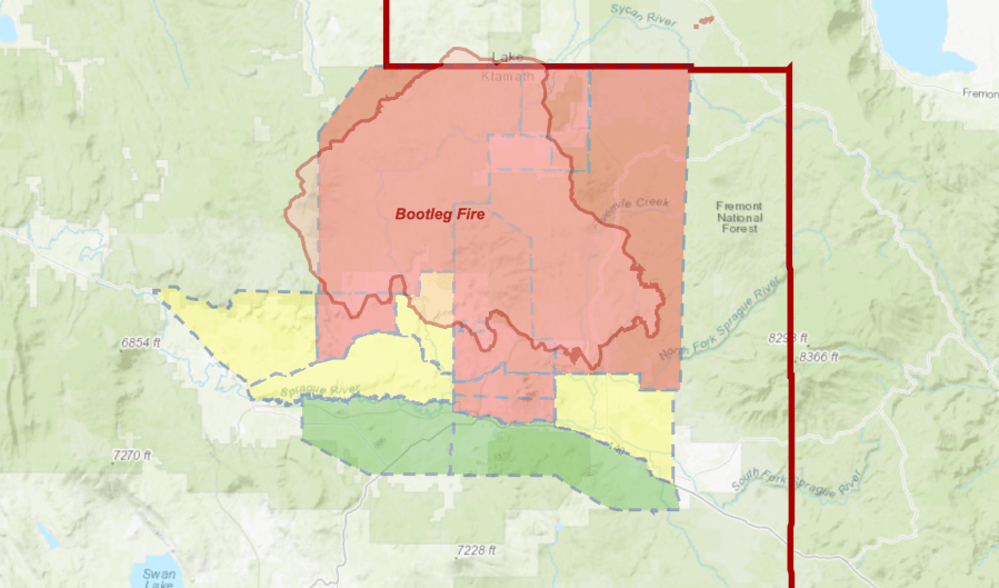
Level 3 “Go Now” – Near the town of Sprague River, including the Upper Tableland area north of Oregon Pines Road, north of the town of Beatty, the east side of Godowa Springs Road, and north of the OC and E Trail to the Klamath County Line.
Level 2 “Get Set” – Near the town of Sprague River, including the Klamath Forrest Estates/Moccasin Hills Area, and the west side of Godowa Springs Road, south of Oregon Pines Road and Tableland Road to the river.
Level 1 “Be Ready” – Between Beatty and Bly, 3 miles south of Highway 140 from Yellow Jacket Springs to Fishhole Creek, and the area from the intersection of Sprague River Road and Forbes Road extending east to Godowa Springs and Yellow Jacket Springs and south of the Sprague River 4 miles.
The Red Cross has an evacuation shelter open at the Klamath County Fairgrounds.
Southern Oregon Emergency Aid and Project Spirit are asking anyone with animals, especially large animals, that are under level 1 or 2 evacuations please consider letting them do a planned evacuation immediately. Anyone interested in this service should text 831-235-3031.
Officials say as the fire advances, there is a high probability for additional evacuation notices in the area.
Local strike team among crews battling blaze
Local crews from Portland, Gresham and Corbett arrived Saturday to help fight the megafire.
Lt. Alan Bronson with PFR said they’ve been protecting homes on the southern flank.
“We did put out some fires last night around several homes,” he told KOIN 6 News. “It’s a real danger. Our goal is to help people save their homes so they have something to come back to.”
Red Cross officials are also working with other local groups to take in livestock, as many of the threatened homes are on working ranches.
“We understand people sometimes get a knock at the door at 3 a.m. and they have to leave right now, without prescription medicine, without clothes, without their glasses,” said Red Cross volunteer Darrell Fuller. “We are here to provide all of those needs.”