Editor’s Note: The Oregon State Forester announced on Aug. 4 that the initial version of the map has been withdrawn. It will be revised after seeking more input from the public.
PORTLAND, Ore. (KOIN) – Oregon has a new state map that shows residents the risk of their property being impacted by wildfires.
The wildland-urban interface and statewide wildfire risk map, which went live on Thursday, is a color-coordinated visual representation of what the wildfire risk is for all of Oregon’s 1.8 million tax lots.
The map was produced by Oregon State University. Each tax lot’s wildfire risk is based on administrative rules adopted by the Oregon Board of Forestry. The rules were determined by a committee and outline boundary criteria for the wildland-urban interface, how each property is assigned to a risk class, how property owners in the extreme- and high-risk classes will be notified of their status, and how property owners can appeal their assigned risk class.
Based on the rules, the Oregon Department of Forestry and Oregon State University determined 4.4% of the state’s land, a total of 956,496 tax lots, is in the wildland-urban interface.
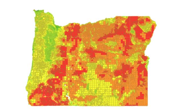
Of all the tax lots in Oregon, 8% of them (120,276) are in the wildland-urban interface and in high- or extreme-risk classifications.
The established wildland-urban interface rules also require property owners in high- and extreme-risk areas to create defensible space or meet building code requirements on their property.
The state estimates about 80,000 of the 120,276 tax lots in the wildland-urban interface have a structure that might need changes to meet new codes or standards.
The Oregon Department of Forestry said it planned to provide written notice to all property owners determined to be in the high- and extreme-risk classes. The notice will inform them that they might need to create more defensible space or make changes to their buildings. It will also tell them how they can appeal their property’s risk classification.
The Oregon Department of Forestry plans to host information sessions to answer more questions about the map’s function and purpose and to better help Oregonians understand the appeals process.
Creating the map was a collaborative effort between the Oregon Department of Forestry, the U.S. Forest Service and Oregon State University.
The map is a result of Senate Bill 762, which passed in 2021. The bill allocated more than $220 million for wildfire preparedness throughout the state.