Check back for live updates throughout Thursday
PORTLAND, Ore. (KOIN) — Wildfires continue to blaze in many regions throughout the state, keeping thousands out of their homes, spewing smoke that makes the air awful and affecting the daily lives of nearly every resident of Oregon.
Here is the latest information for Thursday, September 17, 2020:
Full KOIN 6 News wildfire coverage
Weather suspends some Holiday Farm Fire activity
For 24 hours beginning at 6 p.m. Thursday, operations at the Holiday Farm Fire are suspended for all utility companies and non-essential people from entering the level 3 evacuation area and all areas within the fire footprint.
“No utility crews except those directly related to the Highway 126 snagging operation or Leaburg dam operations will be allowed in the fire areas during this time,” officials said in a statement.
Weakened trees and falling rocks are among the biggest concerns during the rain-wind-lightning forecast. People who didn’t evacuate are “directed to remain at home.”
The Holiday Farm Fire has consumed 170,637 acres and is 10% contained
Overview of Oregon and Washington fires
The Forest Service NW tweeted, “As another day of firefighting begins, crews are confronting 29 large #wildfires burning 1,676,951 acres across Oregon & Washington with: 8,855 Fire personnel, 205 Crews, 510 Engines, 65 Helicopters.”
Both Oregon Gov. Kate Brown and Washington Gov. Jay Inslee will hold press conferences Thursday afternoon. Watch them both on KOIN.com
Big Hollow nears 23K acres
Now up to 22,973 acres, the Big Hollow Fire in Southwest Washington remains at 15% containment as of Thursday morning.
A Level 3 evacuation order remains in effect for Government Mineral Springs and there is still a Level 1 order for north and west of the fire, including Yale, Cougar, Northwoods and parts of Amboy and Yacolt.
Area closures include most developed campgrounds, dispersed camping, most forest roads and trails in southwest Gifford Pinchot National Forest. Closures for the Siouxon Block and Merrill Lake Natural Conservation Area also are in place.
Russian and Spanish translations for updates are available here.
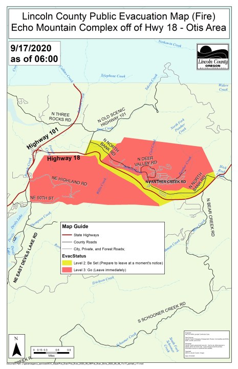
Echo Mountain Fire evacuations downgraded
As crews continue to see progress on containing the Echo Mountain Fire Complex in Lincoln County, more evacuation levels have been downgraded.
As of Thursday morning, the area of N. North Bank Road from Highway 18 to North Panther Creek and the west portion of N. North Bank Road from North Old Scenic Highway 101 to the 0.5-mile marker have been downgraded to Level 2 evacuations.
On Wednesday morning, the Lincoln County Sheriff’s Office announced all previous Level 2 evacuations had been cleared. Lincoln County residents living in the newly downgrade Level 2 area can return to their homes and business at this time, officials said. Be sure to do a safety check once upon returning home.
School Closures
Many school closures remain in place Thursday as wildfires continue to burn across the region. Some schools are continuing with online learning, while others are not. Find a full list here.
Red Cross shelter changes
The Red Cross has closed its wildfire evacuation shelter at the Oregon Convention Center. The Red Cross said Wednesday night the people who evacuated due to fires in Clackamas County have been moved to a nearby Portland motel.
Anyone needing access to the Red Cross shelter should contact the Red Cross at 877.272.7337 or visit visit the Red Cross Disaster Shelters locator.
Oregonians can enroll for health coverage
Since the federal emergency declaration, Oregon residents affected by the wildfires have up to 60 days from the end of the FEMA designation to select a new health insurance plan through HealthCare.gov or make changes to their existing health insurance plan.
Oregonians who were eligible for a standard special enrollment period, but missed this window due to the Oregon wildfires, can use the FEMA SEP to enroll in a plan. Applications are being accepted at HealthCare.gov if the life change is a loss in coverage and at 800-318-2596 (toll-free) for all other life changes.
ODOT assessing roads across the state
The Oregon Department of Transportation is looking at the damage on hundreds of miles of roads, damaged trees, culverts, bridges and guardrails.
ODOT officials said crews will go to each location as conditions allow. They’ve put a new webpage up to show the progress, what they’ve done, where they need to go, plus road information and office closures.
Resources below:
Air Quality: Air quality levels, which were hazardous over the weekend, are expected to remain at unhealthy levels for much of Monday
INTERACTIVE MAP: Air quality conditions in Oregon
Wildfires: Officials said there are 36 wildfires burning in the state
Wildfires in Oregon: Names, locations, size, containment
Evacuations: More than 40,000 fled their homes, and more than 500,000 were in evacuation zones at some point in the last week.
MAPS: Wildfires, evacuation zones in Oregon
Shelters: Shelters are set up around the state, including some that take livestock
LIST: Temporary shelters as wildfires rip through Oregon
The Associated Press contributed to this report.