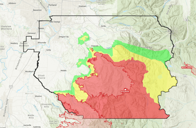
ESTACADA, Ore. (KOIN) –– The Riverside Fire’s trail of destruction was on full display Wednesday as Clackamas County officials surveyed burned areas and cautioned people about the current risk of landslides and falling trees.
The 4th-largest wildfire burning in Oregon, the Riverside Fire is now 31% contained. It has swallowed 138,027 acres since the human-caused fire erupted on September 8.
At least 50 homes and 150 other structures were lost in the fire, though crews are still working to reach some areas and assess the damage so those numbers could increase. Rain and strong winds were expected to move through the area, prompting warnings from fire officials about the dangers of fire-weakened trees.
But the rain is straightforward good news when it comes to the four smaller fires burning in Clackamas County.
“We’ve got those fires looking in really good shape of course they’re much smaller than the bigger Riverside Fire so we’re able to get resources around those a little quicker,” said firefighter Kenny Griffin of North Carolina.
Clackamas County residents whose property was damaged by wildfires can now file reports on the county’s website. The information will be used to apply for federal aid to help rebuild the community.
Report wildfire damage in Clackamas County
There are currently firefighters from 27 states battling the Riverside Fire. “Firefighters continue to hold and patrol firelines along the west and north perimeters. Firefighters are working with partner agencies to mitigate hazards near local communities so that residents can return home safely,” fire officials said.
Evacuation levels
All evacuation levels for the city of Estacada were removed Wednesday, according to the Clackamas County Sheriff’s Office.
Some other changes to evacuation levels were also announced Wednesday: the areas of the Dowty Fire and the Unger Fire have been returned to Level 2. The immediate area surrounding the Riverside Fire remains at Level 3. The Mt. Hood National Forest is still closed.

Sheriff Craig Roberts urged residents to stay out of Level 3 evacuation areas and respect road closures. He said increased traffic in these areas creates additional safety concerns for firefighters and other first responders.
Roberts reported on two cases of arson that happened within the county but were not connected to the wildfires. He said crime has remained low because of increased patrols by law enforcement.
- Additional areas have been removed from evacuation level status and returned to “Normal” — coinciding with the scaling back of Level 1 “Ready” (green) and Level 2 “Set” (yellow) areas across the county.
- The area of the Wilhoit fire has been returned to Level 1 “Ready” (green).
- The immediate areas surrounding the Dowty Fire, Unger Fire, and Riverside Fire remain at Level 3 “Go” (red).
- The City of Estacada is now at Level 1“Ready” (green).
- The Mt. Hood National Forrest remains under a closure order
- The 10 p.m. to 6 a.m. curfew is now in effect for Level 3 (red) areas only.
A temporary flight restriction is still in effect — so fire officials ask that you keep all personal drones on the ground. They say if a drone that is not part of their operation is spotted in the area, they will have to ground all fire aircraft.