PORTLAND, Ore. (KOIN) – Three days in a row of general triple-digit temperatures isn’t an all-time record for Portland — believe it or not, that happened five days from July 13 to July 17, 1941 — but it’s definitely the first time we have hit 105 and above three days in a row.
It’s also the first time that we’ve had a pair of 110 and above days in Portland. However, I want to note that this heatwave is still an issue east of the Cascades, and quite frankly, it’s still going to be hot for some west of the Cascades this week too. We will discuss the ongoing heat and the impact of the heat dome below.
THREE DAYS OF EXTREME ALL-TIME HEAT
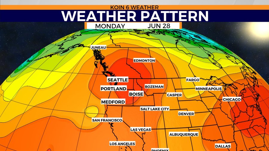
The Pacific Northwest has natural tools to help warm-up and cool off. We are sitting next to the Pacific Ocean, which offers consistent cool air for the summer (we felt that yesterday night in full force). We have a large mountain range that separates the state into two different climates and influences our weather. The combination of a very strong ridge of high pressure and an easterly wind coming down the mountains put us well over the top.
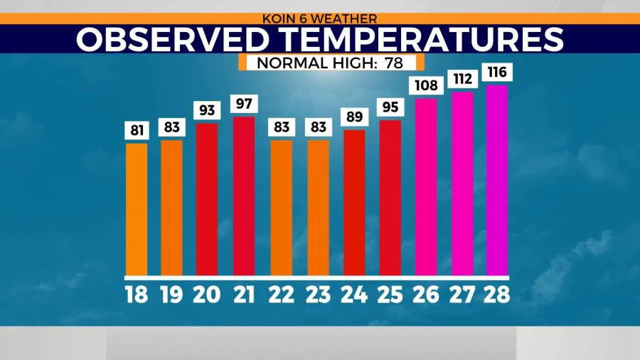
For the most part, Saturday’s high temperature came from the strength of the high pressure that was situated over the PNW. Sunday and Monday both saw an increase in an easterly wind, which took that heat to another level. If you cycle to the next graphic, you can see just how warm it has been for the second half of June, outside of the three-day event.

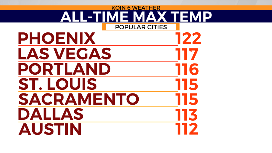
I mentioned that the east wind took everything to the next level. Check out where Portland falls compared to some of other large cities that you would think would have an all-time max temp that would be unachievable for Portland to reach.
We are just one degree below Las Vegas’ all-time record high! Phoenix still has us topped, but we made a push at it. Salem, Oregon hit 117 on Monday. Portland now has an all-time max temperature that is above Dallas and Austin, Texas. With a record temperature of 116 (June 28 day record, all-time June record, all-time Portland record), we were 39 degrees above our average for the day. The average high temperature of 77 was nearly the overnight temperature to start the day.
THE BIG TEMPERATURE SWING
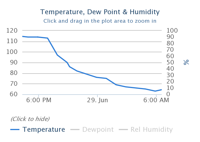
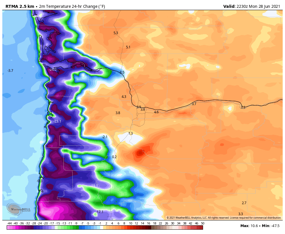
When you’re playing around in desert southwest-type heat, the drop back to PNW temperatures is going to be drastic when it eventually occurs; try a 30-degree drop in three hours from 7 p.m. to 10 p.m. Monday night. The graphic below shows the swift descent and eventual bottom out early today around six in the morning. Using a graphic that showed the temperature change over a 24-hour period, you can see how that cooler air was creeping into the valley yesterday as early as 3:30 p.m. for communities farther south in the valley. There was a moment where Corvallis was in the 70s and Portland was still in the triple-digits, closer to the 7 p.m. hour. This is when the southwest wind started to push the marine air through the channels of the coast range and into the Willamette Valley. It was a welcoming sight and it was also a loud sigh of relief on social media when the air showed up in Portland.
UP ABOVE AND DOWN BELOW
A strong ridge of high pressure perched over the PNW all weekend, before finding just the right placement on Monday to really impact our temperatures in the valley. That dark orange bubble is just about where the core of that high pressure was situated for the afternoon. This kept the east wind coming aloft, but at the surface, the temperature warmed so much that the surface that the pressure became lower, creating what we call a thermal trough.
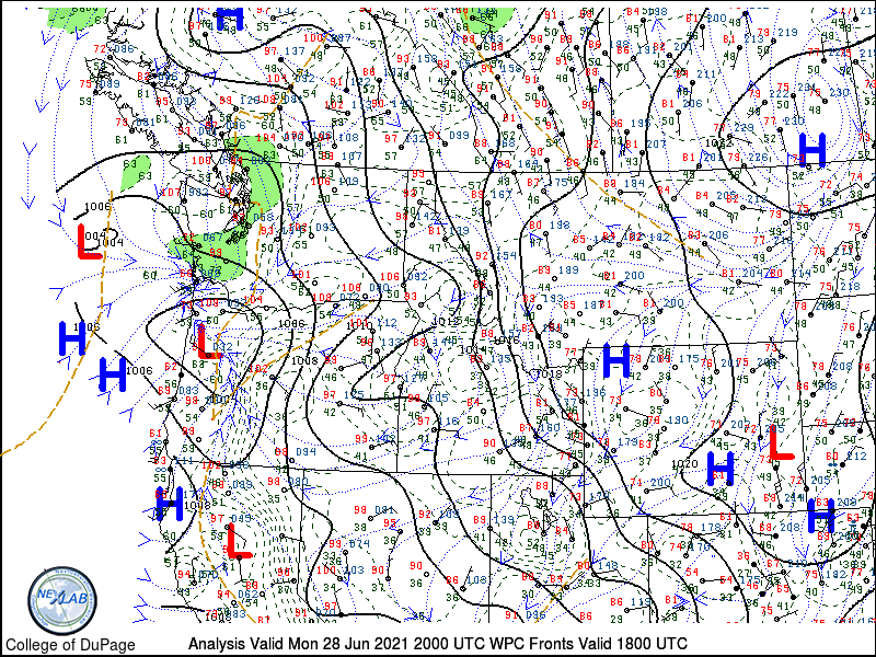
You can see that in the next image, where the mean sea level pressure was 1000 mb, right over the Portland region. This was right at the heart of the heat in Portland, but the cooler air was rushing in on the southwest edge where the wind was shifted.
The third graphic, which is a surface analysis from yesterday around mid-day, also shows that low pressure and the trough associated. This was earlier in the day when the east wind just started cranking, boosting our temperatures to 108 very quickly. The way we operate is layered, which makes forecasting exciting and also detailed.

NOT ONE BUT OVER 20 HOURS ABOVE 100
Up to this point, we haven’t spent a lot of time in the triple-digits in Portland. When we have events that stretch our heat into uncomfortable levels, they are typically short-lived. We may only spend three to four hours above 100 degrees, potentially only touching 100 for an hour. Both Sunday and Monday, Portland spent over eight hours at 100 degrees or above.
When it was all said and done, through the course of the heatwave, we had spent around 23 hours at or above 100 degrees in Portland. It goes without saying, that length of heat will lead to significant problems: power outages, infrastructure failures, human health problems, agriculture concerns, and animal health deterioration. We covered those stories the last three days and we will likely see an impact that goes well beyond the short-term.
THE HEAT IS STILL AROUND
Although relatively cooler air has found a way to the coast and areas of the valley, the overall heat is still overextending its welcome.
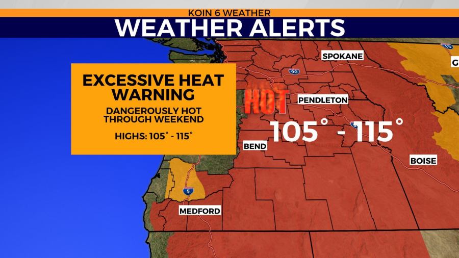
That aforementioned dome of heat is still here, but it is just shifted enough to the east to help communities west of the Cascades. That isn’t the case from about Hood River east into the Columbia Plateau. An excessive heat warning keeps communities on high alert, with ongoing issues to crops and likely animals. Highs in the 105 to 115 range for the next two to three days. This is also adding stress to the fire dangers in the region. Conditions are going to be hot and they are going to be dry. A large temperature gradient from the Oregon coast to the state line of Oregon and Idaho.
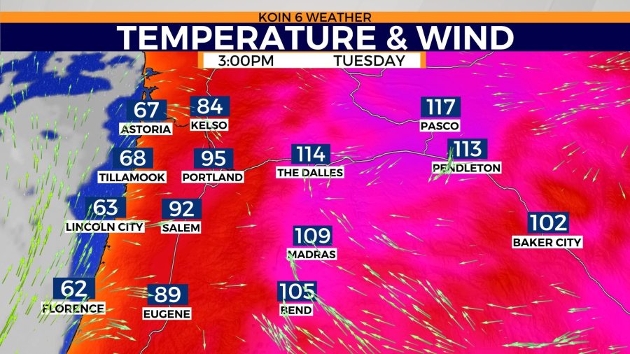
Again, I mentioned above that the ocean and the mountains influence our weather significantly. This is a clear-cut example of that influence. Communities hugging the ocean are much cooler, meanwhile, the mountains are blocking that cooler air from making it too far east.
We will have more in-depth conversations about this heat wave through the course of this summer. We will use this event as we discuss climate change. We will use this event to discuss weather patterns in the PNW. We will use this event as a new bar for our local stats. There is a lot to take away from this historic heat wave.