PORTLAND, Ore. (KOIN) — Time for the song “November Rain!”
The Rose City is going to be diving quickly into the cold November rain this weekend. By the time we finish the first weekend of the month, we may be pushing 60% of our monthly rain total in the first seven days.
There is a chance that we may even push closer to 80% of the monthly rain total. This is due to a strong atmospheric river (AR) coming Friday. Portland has a few more systems riding in behind the AR too. You can read more about it in the article below.
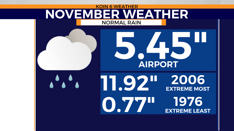
All this rain adds up — November is the second wettest month of the year. The average rain total for the month over the last 30 years comes out to 5.45 inches. That is a healthy dose of water for the region.
If we do some quick math based on the information above, that means Portland and many communities, will be over 3 inches of rain by the time we get to early next week. That also means we may get more rain through the weekend than we did all of October.
If you were debating on purchasing a new rain jacket, you will get use out of it.
Notice that the record monthly total for rain in the month of November is 11.92 inches. It’s hard to say where we will finish for the month, but we are starting with an ambition to break records.
THIS WEEKEND
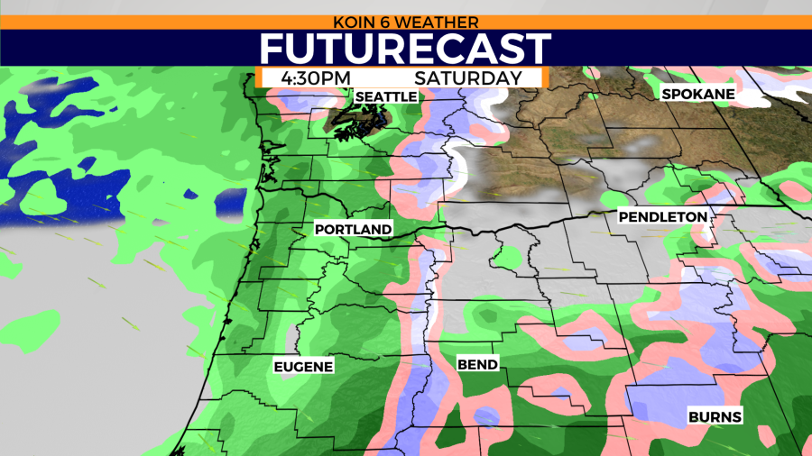
You can expect rain each and every day this weekend. Saturday will be the driest of the three, with Friday evening being a waterlogged landscape. Steady rain will transition more to showers on Saturday before another stream of moisture arrives on Sunday.
If you had plans for the weekend, make sure to plan on that cold November rain. Friday is going to be a day that you want to be indoors. If you have to travel, expect ponding on the roads.

Use the slideshow below to see the most active hours of the weekend. You can tell that Friday is going to be a soaker of a day. We may have record-breaking rainfall this weekend. The record for the most rain for a calendar day in November is 2.69 inches. That occurred on November 19, 1996.
Will this event top that? I don’t believe it will — however, there are some weather models that believe it could be possible.
You will notice that on Saturday that conditions seem lighter. We are not expecting rain like Friday, but we can’t rule out showers and light rain. Sunday will be our next test for steady moderate rain.

ESTIMATED RAIN TOTALS
FRIDAY
Let’s get a general idea of the rain totals by 24 hours across Friday, Saturday and Sunday. Keep in mind that this is the weather data as of midweek. This is only taking into account the weather model that we feel most confident about at this time.
Friday is going to be a soaking wet day. We may see anywhere from 1.5-2.5 inches of rain for the Willamette Valley. The Oregon coast may see anywhere from 2-4 inches of rain. The Cascades may even see more than that, especially in areas of southern Washington.
This is just the timeframe from 12:01 AM Friday to 11:59 PM Friday night. This may rival that 24-hour rain record from back in 1996.

SATURDAY
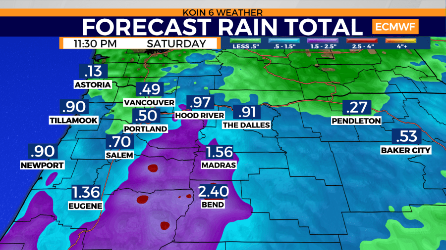
Rain totals will be greater to the south for the completion of Saturday. This is due to the slow-moving atmospheric river dragging south overnight Friday into Saturday morning. When it’s all said and done, it’s possible that Portland finishes the day with half an inch of rain. Most of this will be due to the rain that sticks around beyond midnight Friday.
This is why Saturday may be a bit drier than the rest of the weekend, due to some drier moments in the afternoon. This atmospheric river will also impact those of you in central and eastern Oregon, to some degree, too.
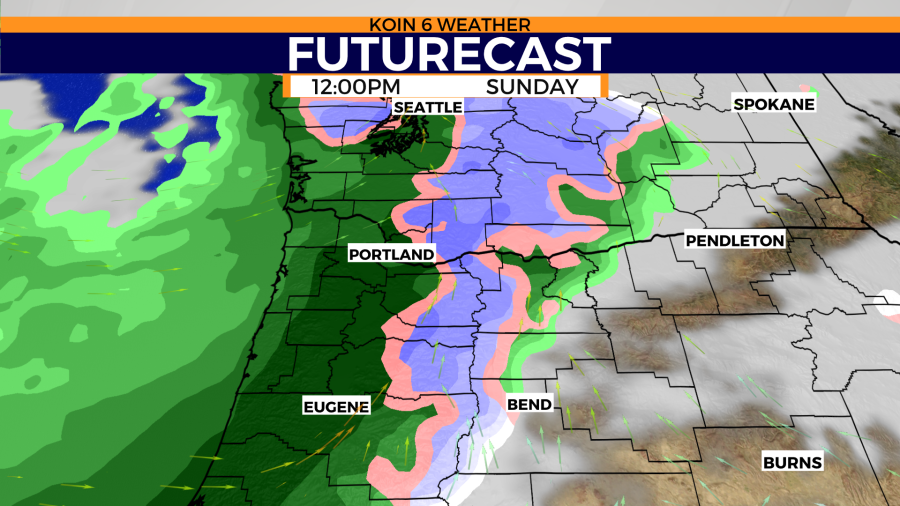
SUNDAY
Washington and Oregon will then jump right back into a fairly soggy situation on Sunday. We have another system that will push through to finish the weekend. This would be all the talk if Friday didn’t exist.
The Willamette Valley is expected to see another half an inch to inch of rain through the day Sunday. Overall, there will be very little time to dry out this weekend.

FULL STORY
You can see here that when it’s all said it done from Friday to Sunday night, many locations are estimated to cross the 3- to 4-inch threshold. This will increase the risk of minor flooding around the region. We are likely to see some weather alerts this weekend as the rain totals climb.
With the nature of this weekend being so wet, there could be structural issues around burn scars and terrain. We may have some minor landslides and debris issues around the region. Make sure to be very careful if you have to travel.
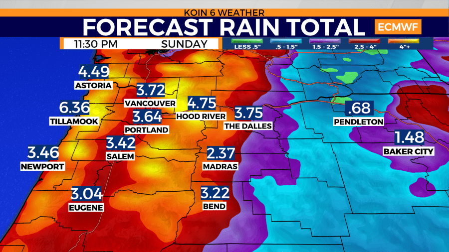
Friday’s rain event will also melt a lot of the snow on the lower elevations of the mountain. We will then do our best to rebuild that snow later in the weekend and next week.