PORTLAND, Ore. (KOIN) — Don’t fret, all you warm-weather lovers — despite some thunderstorms rolling through Oregon on Tuesday, we still have plenty of summer left in the tank to enjoy.
There are 44 days until astronomical fall, but who’s counting? There will be minimal counting in this article. However, we will do the counting for you as we look at how many 90-degree days we have had this year. Why do it now? Because we may have a surge of days coming next week in the extended forecast that can really shake things up.
Let’s set the foundation for the coming weeks now so we can see how much we may build by Aug. 23 (a 14-day outlook final date).
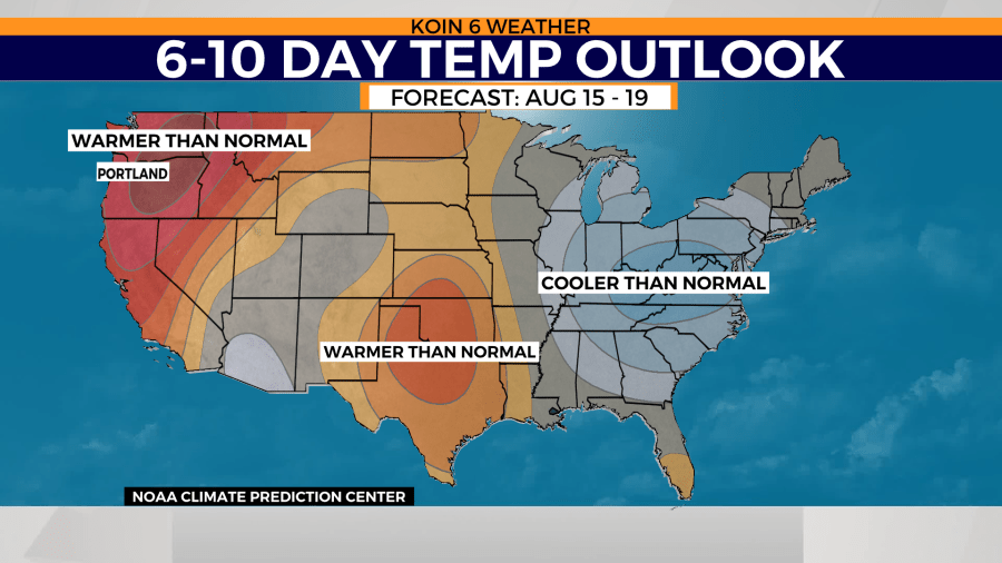
Below, there are two graphics that show the Climate Prediction Center’s temperature outlook for the next six to 10 days, and also, the eight to 14-day outlook. Weather data is leaning towards another stretch of heat for the Pacific Northwest by August 15. That could mean another bout of pressing heat for the Willamette Valley. This likely means the continuation of hot and dry weather for the rest of the state as well.
Both periods are leaning strongly towards a warmer than normal forecast. It is always possible that the weather pattern can shift and the forecast is altered. However, it is more likely that we end up in the scenario that you see in the slideshow below.
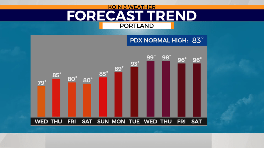
What does a warmer than normal temperature outlook actually look like? It means we are going to be above average. Above average for this time of the year is usually in the upper 80s or breaking into the 90s (overnight temperatures in the mid to upper 60s). There is a confidence that a strong ridge will develop, leading to an extended period of days where the heat is going to be present for Portland and the state.
What we can’t say for certain is how intense the heat is going to be. Some obvious questions: Will the coast be impacted? Will there be dry t-storms for the Cascades? Will we break any records?
What usually comes from this is a trend that we can continue to watch as we get closer to this weekend.
Right now, there is weather data that is projecting temperatures well into the 90s. You can see how the forecast this week goes from near average, or slightly below, straight to a hot spell that would rival some of our warmest days this summer. Don’t put all your chips in on how warm the temperatures are at this time, but be prepared for what is likely going to be some toasty summer days.

The question has popped up if we have come close to our 2018 record for 90-degree or above days in Portland (31 days – graphic below). We have not topped that record, and there is still a gap. Portland has seen 17 days at or above 90 degrees this year. That is a few days above the 1941-2021 average of 15.
There is potential that we get closer to the 2021 total of 24, with the chance to even top that by the time we wrap up the next 14 days. Make sure you keep an eye on the forecast, so you can prepare for the heat.


