PORTLAND, Ore. (KOIN) – It’s that time of the year again: The 230th edition of The Old Farmer’s Almanac is out on Tuesday and you can dive in to all that it offers.
This is always a treat, but take it with your own risk since it has no connection to our KOIN 6 forecast for the upcoming winter.
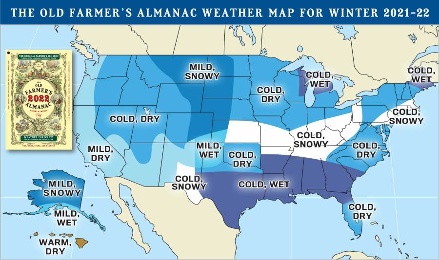
Right off the bat, we have a color scheme that may feel like it’s going to be a cold winter. Digest the graphic below, and then check out what they have to say about the upcoming winter.

A SEASON OF SHIVERS BRRRR! THE OLD FARMER’S ALMANAC IS PREDICTING POSITIVELY BONECHILLING CONDITIONS FOR THIS COMING WINTER THROUGHOUT MOST OF THE U.S. OF COURSE, THERE ARE EXCEPTIONS TO EVERY RULE, BUT“MILD” OR “AVERAGE” TEMPERATURES DON’T NECESSARILY MEAN AN UNEVENTFUL WINTER! FIND OUT MORE BY CHECKING OUT OUR “CHILLING”FORECAST
THE OLD FARMER’S ALMANAC
Well, according to the Old Farmers’ Almanac weather map for the winter of 2021-22, we are actually on a path that may end up mild and dry. That stretches all the way up the contiguous West Coast of the United States. This feels familiar right? At least the idea that we are going to have the dry conditions continue into the winter.
Will that hold up? The winter is when we bring in most of our rain here in the Pacific Northwest (PNW). From our current 1991-2020 climate normal update, Portland receives around 14.48 inches of rain during the winter. We could use every drop of that this year and as much snow as we can get up on the mountains to help us with drought conditions and to help us out for next summer. We will talk more about that in the future.
It does look like they are forecasting a cold forecast for a majority of the United States east of The Rockies this winter. If you’re doing some traveling, you may want to just travel down the West Coast this winter (we will see).
I don’t want to confuse you, but there is also the Farmers’ Almanac, which is also a popular commodity this time of the year.
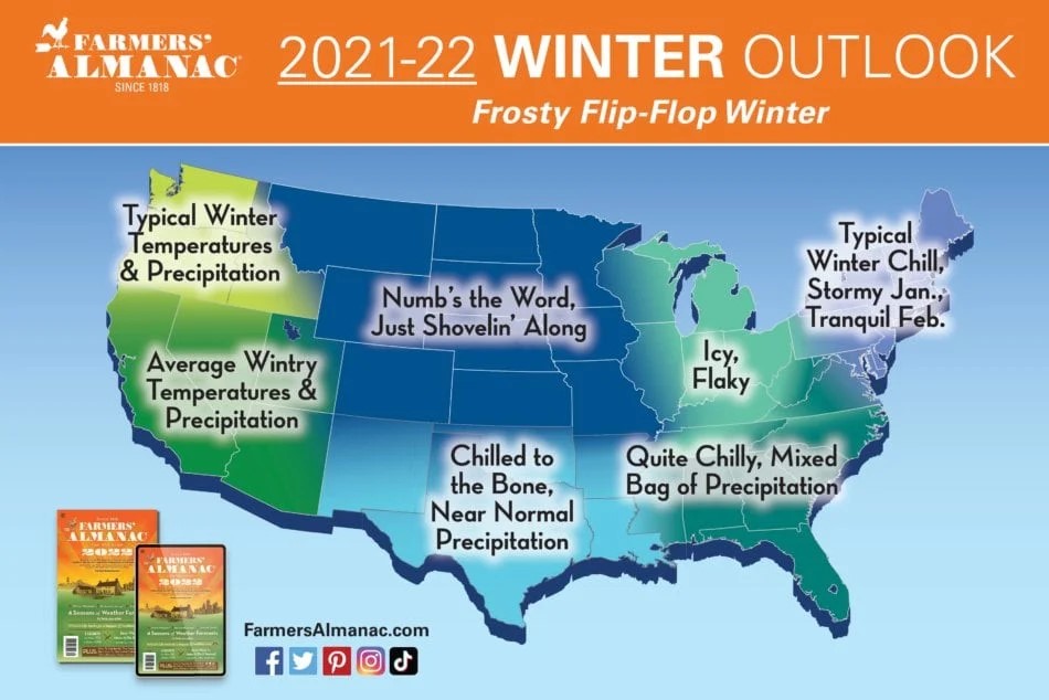
Let’s take a look at what they are going with for the upcoming winter outlook:

I wouldn’t say they are that far off from each other. In this winter outlook, it does have the PNW under typical winter temperatures and precipitation. Just to the south, they have that region marked as average wintry temperatures and precipitation.
We could use our typical winter temperatures and precipitation around here this winter. That means we would get a good amount of rain and our temperatures won’t be that extreme. When we get the rain here, it usually brings snow for the mountains. We can’t argue with that forecast.
Usually, at this time, I would take a look at the Climate Prediction Center’s three-month outlook. Which is usually a long-range forecast for the months of winter. It is not out at this time. They do have the three-month outlook displayed for the fall. We wrote up an article about that (here), which may bring in some more rain. Well, more rain in the fall could potentially mean early snow for the mountains. That is somewhat close to a winter treat!
A reminder that the autumnal equinox doesn’t arrive until Wednesday, Sept. 22. We have some time to enjoy what is left of summer and what will be of fall before we get to winter.