PORTLAND, Ore. (KOIN) — Get your last-minute Christmas shopping done early this week because this is the calm before the storm, so to speak. Models are coming into agreement that a much colder airmass will arrive mid- to late-week, bringing with it modified arctic air and the increasing chance of snow and freezing rain to the Portland metro by late week.
This is likely to have a big impact on your travel plans for Christmas, especially in the Columbia River Gorge. Very cold arctic air will build east of the Cascades this week.
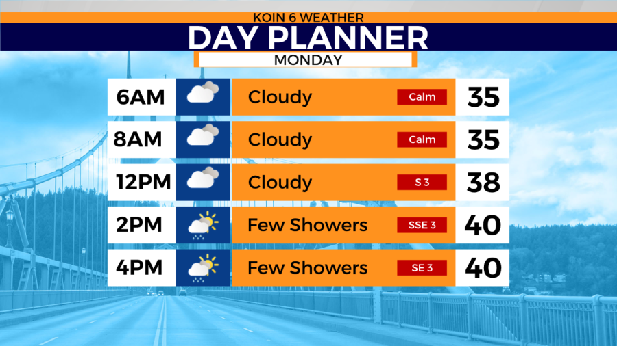
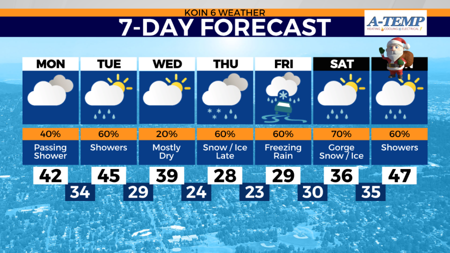
Monday should be a quiet day with lots of dry time. There is only a risk of a scattered shower across the Willamette Valley. Temperatures across the Portland metro will rebound into the low 40s for daytime highs.
What the models reveal now
Models are still coming into final agreement on the exact timing and amounts. This forecast will be updated several times as we get closer to this potentially HIGH IMPACT event just in time for the busy holiday travel week. If moisture arrives as currently modeled later in the week, it has the potential to impact holiday flights in and out of PDX.
The coldest weather of the season is on the way this coming week, with arctic air set to move into Portland metro just in time for your holiday travel plans.
Weather remains mostly dry and mild through Wednesday afternoon. Then Wednesday night strong cold east winds arrive in the metro
Models are in nearly complete agreement now that by Wednesday evening cold east wind will begin to blow through the Gorge and across the metro area. Strong east wind will continue Thursday as arctic air continues to flood in across the metro area, gusting to as high as 30-40mph at PDX and 50-60mph in the Gorge (80mph+ at Crown Point/Vista House.)
Temperatures will plummet by daybreak Thursday into the 20s across Portland and the Willamette Valley with a very cold windchill. Precipitation is then forecast to arrive at some point in the evening Thursday and will likely fall as freezing rain/snow across the metro area through Friday with cold air remaining in place. Temperatures will likely remain at or below freezing in Portland for daytime highs Thursday and Friday.
Travel will become an issue through the Columbia River Gorge beginning Thursday and lasting through Christmas day. The Columbia River Gorge is likely to remain at or below freezing through Christmas.
A hard freeze is expected across all of the metro area and Willamette Valley.
The Portland metro should see improving conditions by Saturday morning (Christmas Eve). Pro tip: Get your last-minute Christmas shopping done by Wednesday evening, if possible.
We are watching this very closely in the KOIN 6 Weather Center and will have several more updates to come on-air and online as the week progresses. Stay tuned!