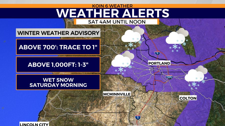
PORTLAND, Ore. (KOIN) – In what feels like a never-ending winter, this first weekend of March starts with a chance for snow in the greater Portland and Vancouver hilltop areas. A winter weather advisory is in effect Saturday early morning until noon targeting elevations above 700 feet.
What’s the probability Portland will actually get snow? The latest examination of forecast models show the valley floor will be too warm for snow to stick. You may get snow splatter on your windshield, aka chunky rain. However, under a more intense band of precipitation you could see snow accumulate in your yard. Your snow meter pegs the “likely category” if you live above 700′ to 1,000′ feet. Take a look below to view potential snow totals in your city.
Rain showers continue into the afternoon with highs in the low 40s. Possible thunderstorms from the coast to valley too! BTW – Portland hasn’t had a high above 50° since Feb. 21!
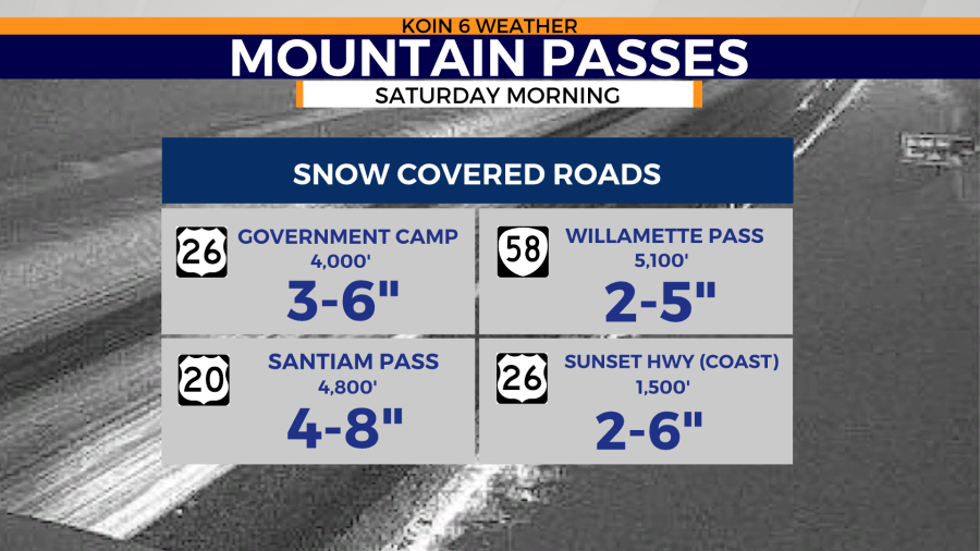
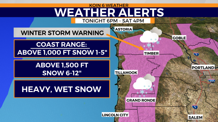
Be aware there is a Winter Storm Warning for the Coast Range Saturday until 4pm with 1-5 inches of snow possible over Sunset Summit. Potentially 6″+ above 1500′ feet. Hwy 26 is already covered in snow at the Sunset Rest Area.
Windy and snowy Saturday for the mountains, so it’s a typical winter day at Mt. Hood. Sunday looks decent for skiing.

Weather alerts
Issued by the National Weather Service, Portland
Winter weather advisory
* WHAT...Wet snow expected. Total snow accumulations of a dusting
  to 2 inches. Snow accumulations as high as 3 to 4 inches
  possible in the higher terrain of the West Hills as well as the
  Banks and Forest Grove area.

* WHERE...Greater Portland Metro Area.

* WHEN...From 4 AM to noon PST Saturday.

* IMPACTS...Plan on slippery road conditions.

* ADDITIONAL DETAILS...Snow levels are expected to lower somewhere
  between 0 and 500 feet late Friday night and continuing through
  Saturday morning. The most likely outcome for the valley floor
  is a dusting to 1 inch, but there is a 20-30% chance of snow
  amounts in excess of 1 inch on the valley floor if precipitation
  rates become heavy enough early Saturday morning. It appears
  rain will switch over to wet snow over the Portland metro by 3-4
  AM PST Saturday before switching back to rain around 10-11 AM
  PST Saturday.
Winter storm warning
* WHAT...Heavy wet snow expected above 1000 feet. Total snow
  accumulations of 6 to 12 inches above 1500 feet, except 1 to 5
  inches below 1500 feet.

* WHERE...Coast Range of Northwest Oregon.

* WHEN...From 6 PM this evening to 4 PM PST Saturday.

* IMPACTS...Travel could be very difficult.

* ADDITIONAL DETAILS...Heaviest snow expected to occur late Friday
  night through Saturday morning. Brief periods of 1 inch snowfall
  per hour possible above 1000 feet during that time.

PRECAUTIONARY/PREPAREDNESS ACTIONS...

If you must travel, keep an extra flashlight, food, and water in
your vehicle in case of an emergency.