PORTLAND, Ore. (KOIN) — This is the day we’ve all been anticipating. There are so many hopes and dreams hanging on these little jewels from the sky.
So, when will the rain make an appearance? Friday morning is our transition from hopeless haze to clouds, then rain. If you feel something dropping on your head, it’s not a passing bird, it’s R.A.I.N.! This should occur sometime between 10 a.m. and 1 p.m. for Portland.
And with this cold front comes a stronger onshore flow. This will help further scour out the lingering smoke.
In fact Thursday, for the first time in 3 days, Portland’s air quality finally dropped out of the unhealthy for everyone category. A word of caution, though. An air quality advisory will remain in effect through Monday. Even with a good dose of rain, fires will likely be smoldering, affecting those communities in close proximity.
The highest rain totals are expected over Southwest Washington and Portland. Totals could range from 0.80″ to 1″ on Friday. Heaviest rain periods will be Friday afternoon and late night.
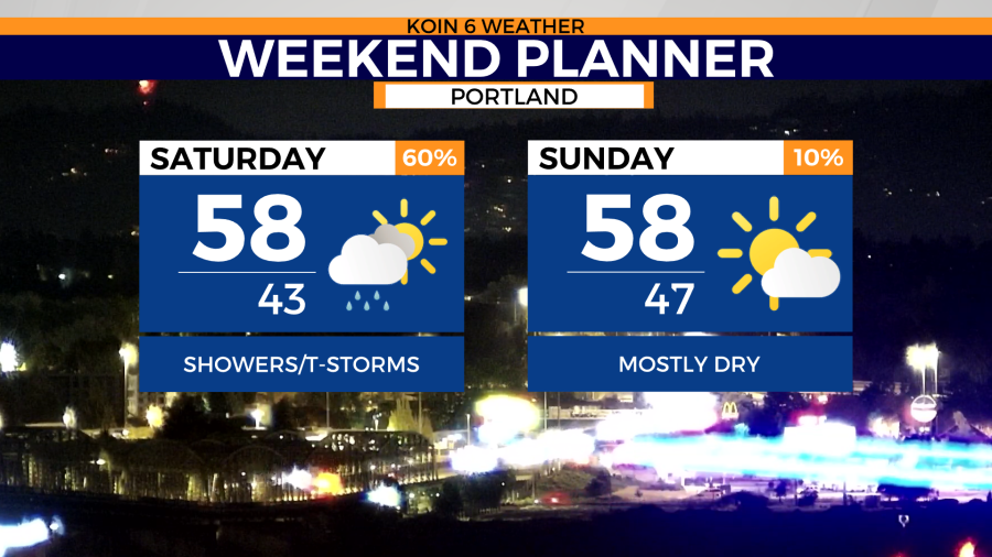
As cold air arrives three things are possible: max temperatures in the 50s, thunderstorms Saturday and mountain snow.
Mountain passes may briefly encounter snow accumulations under the heaviest snow showers. But we’re coming into this pretty warm so I wouldn’t expect long lasting impacts on passes. I’d watch Willamette Pass and Santiam Pass. Sunday looks mostly dry. Then we’re right back to rain for most of next week.
Swipe through the graphics below for a snapshot of this weekend’s forecast.