
Editor’s note: The KOIN 6 Weather team is presenting weather and science lessons to help serve our teachers and students. Click here for more lessons.
PORTLAND, Ore. (KOIN) – One of life’s pleasures is sitting back and watching the clouds. It’s a natural joy and something that everyone can connect with.
You’ll notice different types of clouds from day to day, and of course, they all represent something that is going on in our atmosphere.
From just observing the sky, the clouds can be big, small, dark, bright and even represent different shapes and animals. Clouds are sometimes closer to the surface and other times they’re way up there where the airplanes fly. Well that is one way to group the clouds and today you’ll learn a little about the classification of clouds!
First there are three Latin words that represent some of our basic clouds:
Stratus (Latin for “layer”), Cumulus (“heap”), and Cirrus (“curl of hair”).
Using those words and a few additional words, 10 basic types of clouds are established. This cloud classification has been around for a long time (dating back to 1802). Are you ready?
High-Level Clouds


(From left to right: Cirrocumulus (Cc) , Cirrostratus (Cs), Cirrus (Ci))
Above are three types of clouds that are considered to be “high-level” clouds. These are clouds that range from 16,000 to 43,000 feet. These clouds are cold and composed of ice crystals. They’re mostly white for the exception of early and late in the day near sunrise and sunset. A common high-level cloud would be cirrus clouds, which are wispy.
Mid-Level Clouds


(From left to right: Altocumulus (Ac), Altostratus (As) – you may also see nimbostratus in this category from time to time)
The mid-level clouds are typically from 6,500 – 23,000 feet in the middle latitude region like Portland. You’ll notice that there is some cross over.
These clouds are built of water droplets and potentially some ice crystals. These clouds may create precipitation too if they’re thick enough.
Go through some of the photos above and really get a good look at what those clouds look like!
Let’s move on to the clouds that may feel a little more intimate or part of your daily life…the low-level clouds.
Low-Level Clouds


(From left to right – Cumulus (Cu), Stratocumulus (Sc), Stratus (St), Cumulonimbus (Cb), Nimbostratus (Ns))
Low clouds have a range from the surface to 6,500 feet (base of the cloud). Low clouds are composed of water and will produce rain.
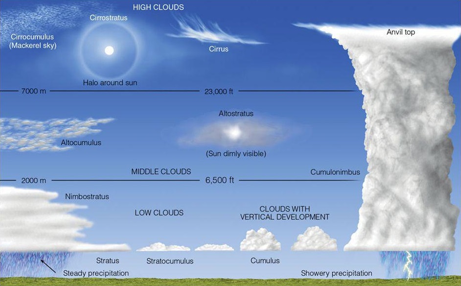
Some low clouds have a base that start in the lower levels and build up to 10,000 feet or more into the other levels. An example of a cloud that would do that is the Cumulonimbus cloud, you can think of a tall storm cloud with rain and lightning. Cumulus clouds develop vertically and often resemble cauliflower or images in the sky. Below is a popular chart that you will see in weather and climate courses.
This is just the beginning of our cloud course – we will learn more about each type of cloud in a future course. In the meantime, look out the window and see if you can determine which type of cloud is out there!