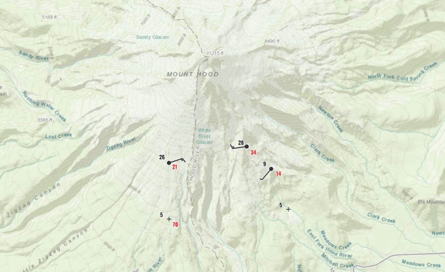
PORTLAND, Ore. (KOIN) — Thursday’s flux of freezing, arctic air is creating topsy-turvy temperatures on Mount Hood ski slopes.
National Weather Service temperature data shows that throughout the day, the upper portion of Mt. Hood Meadows’ ski slopes has been roughly 20 degrees warmer than the bottom of the slopes. At 7 a.m. Thursday, temperatures at the top of the slopes were recorded to be 28 degrees. Conditions at the bottom of the slopes, meanwhile, were an icy 3 degrees.

The weather anomaly is still actively occurring.
As of noon Thursday, the temperature at the top of Mt. Hood Meadows was 28 degrees. The temperature at the bottom of the slopes was 5 degrees. National Weather Service Meteorologist Colby Newman told KOIN 6 News that this unusual event is caused by colder, low-lying air flowing into the region.
“The reason behind that is the cold arctic air coming into the region is down near the ground,” Newman said. “It’s basically funneling through the valleys.”
The upper half of the colder low-lying air, he said, is situated between 6,500 and 7,300 feet of elevation. Mt. Hood Meadows’ highest point is around 7,300 feet in elevation. As a result, anyone taking a chairlift from the bottom of the ski resort to the top could see a temperature increase of roughly 25 degrees.
“The same thing is happening over Portland right now and it’s going to be magnified here over the next several hours,” Newman said.
These colder low-lying temperatures are likely to cause sleet and freezing rain as precipitation moves into the region today. Click here to read about the differences between sleet, snow and freezing rain. If freezing rain does occur, it’s expected to create hazardous conditions around Portland.
“It will freeze on trees, cars, on the roads,” Newman said. “That’s freezing rain.”
