
PORTLAND, Ore. (KOIN) – Snowpack levels are well above average across Oregon as the state endures a cold, wet spring. Some say the chilly weather is worth tolerating if it results in a milder wildfire season, but scientists say that will depend on a lot more than snowpack.
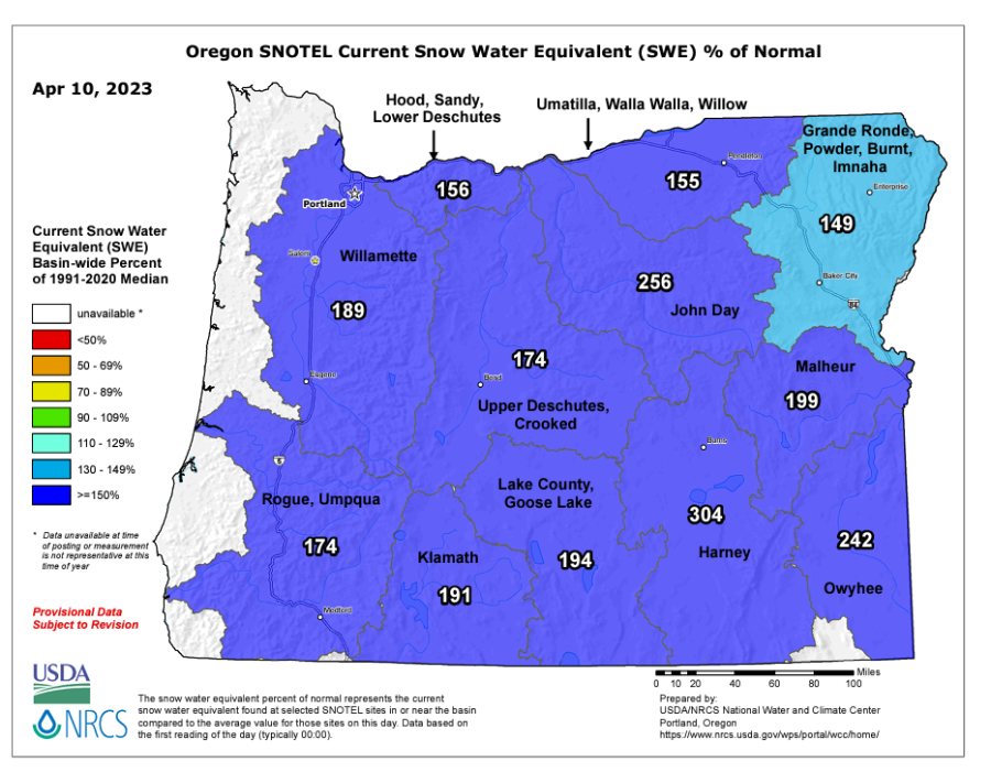
As of Monday, April 10, almost the entire state had snowpack levels at or above 150% of median levels. The Harney County area was as high as 304% of its median snowpack, according to the Natural Resources Conservation Service.
While this seems promising in a state that has been experiencing drought for the last several years, Erica Fleishman, director of the Oregon Climate Change Research Institute and a professor at Oregon State University, said precipitation levels across the state have been below normal and that’s concerning.
“It’s been cold and that helps to maintain the snow, but precipitation totals from January through March were on the low side,” she said.
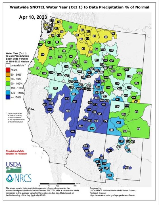
According to data released by the Natural Resources Conservation Service on Monday, the Willamette Valley has only received 89% of its median precipitation in the water year, which began October 1, 2022.
If the spring continues to be cool and wet, Fleishman said it could push back the start of wildfire season. On the other hand, if the rain stops and the temperature climbs rapidly, wildfire risk conditions can quickly return.
Fleishman said there’s no set number of dry days that makes wildfire season more likely to start. It all depends on how moist the plants are and how dry the air is in wildfire-prone areas, and the likelihood of an ignition.
Wet weather in March and April can be a good sign for pushing back the fire season, but it can create another problem. Sometimes the increased rain can cause non-native, highly flammable grasses to grow quickly, especially east of the Cascades.
The Oregon Climate Change Research Institute doesn’t have any predictions of what to expect during the 2022 wildfire season, but Fleishman said over the last several decades, trends show that there have been more frequent and somewhat larger wildfires.
“Every year it is different and there’s so much chance involved in whether there’s an ignition and whether it spreads,” she said.
People can’t control the weather, but they can control themselves. By being careful while building fires or burning debris, people can help prevent wildfires from starting, especially during hot and dry conditions.
When asked which situation is preferable, a winter that’s more wet than usual or a gradual warm-up to summer, Fleishman said both because a gradual warm-up means the snowpack Oregon has will last longer.
“Ideally that snow that snowpack melts relatively slowly, and the ground can absorb the water and you sort of have a steady water supply the melt isn’t really flashy,” she said.
KOIN 6 News meteorologists say the April showers will stick around and temperatures will continue to remain cool. Daytime highs in Portland will remain in the 50s, about 10 degrees below the city’s average temperature for this time of year.
The atmospheric river that’s bringing rain to Portland Monday is depositing more snow in the Cascades.